

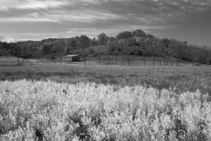
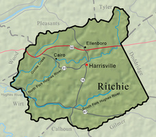
Ritchie County was carved out of portions of Wood, Lewis, and Harrison counties on February 18, 1843. Situated in northwest West Virginia, Ritchie County has an area of 453.7 square miles and is traversed by four-lane U.S. 50 and several secondary roads. The county is drained by two forks of the Hughes River and by numerous creeks, including 30-mile-long Goose Creek. There are many narrow but fertile valleys and gentle uplands suitable for livestock raising and the county’s generally small farms.
Named for a Virginia journalist and politician, Thomas Ritchie, the county is known for its oil and gas production. Ritchie County was home for 50 years to George Lemon (1788–1866), a pioneer in the petroleum industry. The county seat is Harrisville.
In 1822, Thomas Harris, who had moved westward from Clarksburg in 1807, laid out the community which by 1833 was known by the post office name of Solus. The place experienced little growth before the 1843 birth of Ritchie County. Three years after that important event, Solus was renamed Ritchie Court House. In 1895, the town’s founder was honored, along with his nephew, Gen. Thomas M. Harris, by the new name, Harrisville.
The first settler of European descent within the present boundaries of Ritchie County was John Bunnell, who built a cabin by 1800 at the present site of Pennsboro. Sometime before 1810, John Webster bought Bunnell’s property and built the Old Stone House, a large structure which is now included in the National Register of Historic Places. The town of Cairo (once known as Egypt, and also called the McKinney Settlement) was renamed Cairo when a Baltimore & Ohio Railroad station was located there in 1856. The village of Petroleum, important to the development of the oil industry, is a dozen miles west of Cairo, on Goose Creek.
One of the first residents in the northeastern section of the county was Daniel Haymond, who settled near the head of the North Fork of the Hughes River in 1817. A son of William Haymond of Harrison County, Daniel Haymond was twice elected a Virginia state senator. The Haymond settlement grew sufficiently to acquire the name of Federal Hill, and by 1850 there were 200 residents. Its name was later changed to Mole Hill. This name lasted until 1949, when the residents of Mole Hill agreed to let the name be changed once again, this time to Mountain. Making a Mountain out of Mole Hill was a publicity stunt encouraged by the Borden Milk Company and its New York advertising agency.
Ritchie County was well served by Virginia’s 19th-century road network. In the late 1830s, the Northwestern Virginia Turnpike, originating in Winchester, was built through the county and on to Parkersburg. The county’s population doubled by 1850, and had nearly doubled again 10 years later. The turnpike (now U.S. 50) for many years collected tolls at Tollgate, a village in eastern Ritchie County.
A few years later, the Staunton-Parkersburg Turnpike (called the Staunton Pike, now State Route 47) was built through the southern section of Ritchie County. It followed the South Fork of the Hughes River from Smithville to Cisco. Smithville was named after Barnes and Aaron Smith. When Smithville was planned, sometime around 1844, a street was named for the one-time engineer for Napoleon, Claudius Crozet, who served as the Virginia state engineer when the Staunton-Parkersburg Turnpike was built.
The Ritchie Mines, an unusual natural asphalt deposit, was discovered by Frederick Lemon, the son of George Lemon, in 1852, near Macfarlan. In 1859, Frederick Lemon sold the property, which was mined until the early 20th century.
The early oil and gas and timber industries led to the construction of railroads, including the Cairo & Kanawha (the C&K, also known as the Calico), the Pennsboro & Harrisville, the Harrisville Southern, and the Sand Hill & Laurel Fork.
Ritchie County today produces timber, with lumber products a chief industry. Simonton Windows near Ellenboro manufactures windows for houses, offices, and commercial buildings. Glassware, marbles, and clothing are also manufactured in the county. Oil and gas wells, some still producing after many years, punctuate the countryside, and from time to time new wells are drilled.
While Ritchie County lost a third of its residents in the first half of the 20th century, the county’s population stabilized after 1960. The 2000 population was 10,343 but decreased by 19.2 percent between 2010 and 2020, when the county had 8,444 people. Ritchie County is served by four banks and two newspapers. Its students attend the consolidated Ritchie County High School and several elementary schools. North Bend State Park, located on the North Fork of Hughes River near Cairo, features a 30-room lodge, eight cabins, and two riverside campgrounds.
As of 2022, the largest employers were, respectively, Simonton Windows, Hall Drilling, the county school system, Jay-Bee Oil & Gas, and T.L.N. Four.
This Article was written by R. F. Hendricks
Last Revised on November 20, 2023
Related Articles
Sources
Puetz, C. J. West Virginia County Maps. Lyndon Station, WI: Thomas Pub..
Lowther, Minnie Kendall. History of Ritchie County. Wheeling News Litho. Co., 1911.
Ritchie County Historical Society. The History of Ritchie County, West Virginia to 1980. Harrisville: 1980.
Hendricks, Ronald F. Mole Hill or Mountain?. Parkersburg News, 10/17/1999.
Cite This Article
Hendricks, R. F. "Ritchie County." e-WV: The West Virginia Encyclopedia. 20 November 2023. Web. 26 July 2024.

Comments?
There aren't any comments for this article yet.
Click here to read and contribute to the discussion →