

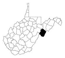
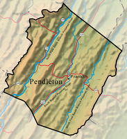
Created on May 1, 1788, largely from Rockingham County, and smaller portions of Augusta and Hardy, Pendleton County was named for Virginia statesman Edmund Pendleton (1721–1803). Bounded on two sides by Virginia, it adjoins the Shenandoah Valley. Its surface area, 698.1 square miles, ranks fifth-largest in the state. Franklin is the county seat and only incorporated municipality.
Pendleton’s three parallel valleys are drained by the Potomac’s South Branch and its tributaries. Spruce Knob in the county’s southwestern corner rises to 4,861 feet, the highest elevation in the state. Pendleton’s total vertical relief of 3,708 feet, the distance from the highest to lowest points, is the greatest of West Virginia counties. The county has 295 known limestone caves, whose aggregate mapped length totals nearly 37 miles. Pendleton County is spectacularly beautiful, with scenic features including Seneca Rocks, Champe Rocks, Germany Valley, Seneca Caverns, and the Smoke Hole canyon.
The first known settlement of European descent had occurred by 1740 near present Cherry Grove on the North Fork of the South Branch. By 1747, several families had acquired lands at Fort Seybert on the South Fork, and shortly thereafter at Upper Tract on the main South Branch. Germans were most numerous among the early settlers. German culture became concentrated especially in the vicinities of Sugar Grove and Thorn Creek, where a German-speaking tradition persisted among elderly residents into the late 20th century.
The area, then part of Augusta County, was exposed to Indian raids during the French and Indian War. In 1758, Shawnees led by Killbuck subdued Forts Seybert and Upper Tract, killing dozens of settlers and militia. Hinkle’s Fort in Germany Valley escaped destruction and continued through the Revolution. Only one Indian raid, in 1781, occurred in Pendleton after 1764. During the American Revolution the people’s sympathies were divided, with a significant Tory presence.
From 1790 to 1860, Pendleton’s population increased from 2,452 to 6,164; there were 50 free blacks and 244 slaves in 1860. Franklin, formerly known as Frankford, was chartered in 1794. In 1821, territory was lost to Pocahontas County, and the northern half of Highland County, Virginia, was taken from Pendleton when that county was formed in 1847. Subsequently Pendleton’s borders have remained unchanged. The niter and gunpowder industry, particularly at the Trout Rock caves, was important during the War of 1812. For nearly a century before 1860, Pendleton stockmen participated in the South Branch’s prosperous cattle industry. Perhaps the most notable antebellum citizen was William McCoy, who served 22 years (1811–33) in the U.S. House of Representatives, part of this tenure as chairman of the House Ways and Means Committee. McCoy’s Mill, whose predecessor mill was built at the mouth of Thorn Creek by Ulrich Conrad about the time of the French and Indian War, remains a local landmark today.
During the Civil War the county government and a majority of citizens supported the Confederacy. More than 700 Pendleton soldiers fought for the South. But Unionists in the Seneca and Brushy Run sections contributed several hundred men to Home Guard companies. The result of divided allegiance was vicious guerrilla warfare in the county. The most prominent leaders of the respective sides were brothers: Confederate James Boggs and Unionist John Boggs. The Confederate Niter and Mining Bureau operated the saltpeter works at Trout Rock, which were raided repeatedly by federal forces. After the war, William H. H. Flick, a Union veteran who served as Pendleton’s delegate to the West Virginia legislature, introduced the Flick Amendment, which in 1870 restored the voting rights of ex-Confederates.
At least four railroad projects were proposed during the next 40 years, but none materialized. Pendleton never obtained a permanent railroad, although several temporary logging railroads penetrated the county in the early 20th century. In 1918 and 1920, the newly created Shenandoah and Monongahela national forests were extended into the county’s eastern and western reaches. The Shenandoah National Forest was renamed for George Washington in 1932.
Several crises struck Pendleton between the two world wars. In April 1924, a catastrophic fire destroyed the business district of Franklin. In addition to economic depression and severe drought, the failure of all three county banks in 1931, and the absence of a bank until 1937, reduced many residents to barter. The county benefited from federal projects during Roosevelt’s New Deal, including the building of 300 miles of improved roads and increased state aid to schools. Ralph M. Hiner of Franklin served as speaker of the House of Delegates from 1933 to 1935. County population peaked at 10,884 in 1940. During World War II, army mountain troops trained on Seneca Rocks and other crags. The war spurred massive out-migration, which would continue to 1970, when the census recorded a population of 7,031.
Pendleton County’s population was 6,143 in 2020. Agriculture has continued as the economic mainstay, especially livestock and poultry. In 2012, the average size of the county’s 556 farms was 306 acres, the second largest acreage of any county in West Virginia. Pendleton also ranked second in its number of broilers and third in chicken eggs. In 2015, it led the state in raising sheep and lambs.
Major employers have included Greer Lime Company (since 1960) in Germany Valley; Allegheny Wood Products (since 1973) at Riverton; and the Pendleton Manor nursing home (since 1975) at the county seat. The 2021 median household income was $46,506, slightly below the state average. The county’s largest employer in the late 20th century, the Hanover Shoe plant, which had a peak work force of about 700 and about 360 in mid-1999, ceased operations in January 2000.
As of 2022, the largest employers were, respectively, the county school system, Pendleton Manor, Greer Industries, Allegheny Wood Products, and Pendleton Community Care.
In 1965, Congress created the 100,000-acre Spruce Knob-Seneca Rocks National Recreation Area. The Treasure Mountain Festival, held at Franklin each September, was inaugurated in 1969. That same year the U.S. Navy began operating a major communications center at Sugar Grove. Not until 1977 did the North Fork area acquire modern dial telephone service, replacing vintage hand-crank telephones. The worst natural disaster in the county’s history occurred in November 1985 when raging floodwaters killed 16 people and inflicted severe property damage. Except for neighboring Pocahontas County, the population density of Pendleton County is the lowest in the state.
This Article was written by John Craft Taylor
Last Revised on November 21, 2023
Related Articles
Sources
Boggs, Elsie B. A History of Franklin: The County Seat of Pendleton County. Staunton, VA: McClure Printing, 1960.
Calhoun, H. M. 'Twixt North and South. Franklin: McCoy Pub., 1974.
Cite This Article
Taylor, John Craft "Pendleton County." e-WV: The West Virginia Encyclopedia. 21 November 2023. Web. 27 July 2024.


Comments?
There aren't any comments for this article yet.
Click here to read and contribute to the discussion →