

Mason County was created on January 2, 1804, from part of Kanawha County. There is uncertainty over the naming of the county. It is commonly thought that Mason County was named for Virginia statesman George Mason, an American founding father and principal author of the Bill of Rights. George Mason died barely a dozen years before the creation of Mason County and is the most prominent Virginian ever to bear the surname. However, George Mason’s nephew Stevens Thomson Mason, a Virginian and U.S. Senator, had died less than a year before the creation of the county. Historian Virgil Lewis, a Mason County native, originally thought that the county was named for George Mason but later decided it was named for Stevens Thomson Mason. The Virginia legislature only rarely specified a particular namesake in naming a new county, and did not do so in the case of Mason County. With Stevens Thomson Mason’s death freshly in mind and with no Virginian likely to forget George Mason, perhaps the intent was to honor the distinguished family.
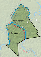
The Ohio River forms the western boundary of Mason County, and the Kanawha River divides its northern and southern parts. Mason has long been a leading agricultural county, producing milk and livestock, corn, hay, tobacco, and orchard fruit.
The size of the county is 445.2 square miles. Low-lying land is regularly visited by floods, which were disastrous in 1913 and 1937. On March 30, 1913, the Ohio River at Point Pleasant reached a record 62.80 feet, more than 22 feet above flood stage. On January 27, 1937, the river crested at 62.70 feet.
The interior of Mason County is hilly and forested with oak, maple, hickory, and Virginia pine. The highest point is about 1,300 feet. The population in 2020 was 25,453, down from its peak of 27,045 in 1980. The biggest town is historic Point Pleasant, the county seat, which lies at the confluence of the Kanawha and Ohio rivers.
A Shawnee village existed at Old Town Creek until about 1765. John Peter Salling’s party descended the Kanawha River and reached the Ohio on May 6, 1742. French explorer Celoron de Blainville buried a lead plate at the mouth of the Kanawha in 1749. Christopher Gist surveyed the Ohio Valley as far as the Kanawha in 1751.
In the autumn of 1770, George Washington surveyed some 52,000 acres of Ohio River bottomland from Point Pleasant to Letart, which would later be divided among fellow officers as bounty land for service in the French and Indian War. Washington’s companions, Andrew Lewis, George Muse, Peter Hogg, Andrew Stephens, Andrew Waggener, John Polson, John West, Charles Thurston, Dr. James Craik, and Hugh Mercer would be among the first settlers of the county. Washington also surveyed a tract of 10,900 acres for himself on the south side of the Kanawha. In 1774, Washington sent agents to clear and build on the land, but this plantation was abandoned during the Revolutionary War, along with plans for a colony named Vandalia which was to have had its capital at Point Pleasant.
On October 10, 1774, a force of 1,100 Virginians under General Andrew Lewis was attacked at Point Pleasant by Shawnee Indians led by Chief Cornstalk. In the battle, Col. Charles Lewis, brother of Andrew, was killed, along with 150 other white militiamen and an unknown number of Indians, before Cornstalk withdrew his warriors across the Ohio. The Battle of Point Pleasant was the only engagement of Lord Dunmore’s War.
Shortly afterward, Fort Blair was built near the battle site, succeeded by Fort Randolph, but permanent settlement of Mason County did not begin until after the Revolution. The town of Point Pleasant was chartered by the Virginia Assembly on December 19, 1794, on land belonging to Thomas Lewis. Daniel Boone was a resident during the 1790s. Other early residents included Anne Bailey, frontier scout. German families from the Shenandoah Valley settled in the Graham Tract, in the northern part of the county, purchased by John Roush, an early sheriff. Mason County was formed in 1804. In 1820, the population of the county was 4,868.
During the Civil War, military action was limited but included a Confederate cavalry raid at Point Pleasant on March 30, 1863. Mason County’s most famous Civil War figure is Confederate General John McCausland, who grew up in the Kanawha Valley and returned to a farm near Pliny after the war.
Mason County was well represented in the West Virginia statehood movement. Charles B. Waggener was one of three secretaries of the First Wheeling Convention on May 13, 1861. In the Second Wheeling Convention, Daniel Polsley of Mason County was selected lieutenant governor of the Reorganized Government of Virginia. John Hall was president of the West Virginia Constitutional Convention, and John M. Phelps was elected president of the senate in the first West Virginia legislature, which met in Wheeling on June 20, 1863.
The economy of Mason County was diverse and flourishing by the mid-19th century. Abundant timber supported a boat yard at Letart and a later shipbuilding industry at Mason and Point Pleasant. Sand and gravel quarries, oil and natural gas wells, and coal mines were developed. Mining began in West Columbia (where George Washington had seen a ‘‘coal hill on fire’’) in 1847 and neighboring Clifton in 1853. Mining continued until the 1960s. In the 1850s and late 1860s, entrepreneurs from Connecticut founded the towns of New Haven and Hartford in the Pomeroy Bend area. The city of Mason was incorporated in 1856. These three towns became centers of a booming new industry based on salt brine. At Mason, Dr. H. Stieren of St. Louis established a bromine factory in 1868 which became the largest producer of bromine in the world. A Mason County native, Michael J. Owens (1859–1923), invented a bottle-making machine and became a key figure in the American glass industry. The State Hospital for the Colored Insane and the State Industrial School for Colored Boys were established at Lakin in 1923.
Industry continued to develop through the 20th century, the products including polyester resins, plastic film, TNT, synthetic hydraulic lubricants, metal alloys, malleable iron casting, furniture, dresses, and ceramic insulators. Marietta Manufacturing Company began an operation at Point Pleasant in 1916 and produced small ocean-going craft during World War II. The electric power industry became a major employer after World War II with the construction of the Philip Sporn plant at Graham Station and the Mountaineer plant at New Haven.
River commerce has been important throughout the county’s history. The Gallipolis Locks and Dam was constructed in 1933–37. One of the largest such facilities in the world when built, it has since been replaced by the Robert C. Byrd Locks and Dam.
On December 15, 1967, the Silver Bridge at Point Pleasant collapsed into the Ohio River, plunging some 50 vehicles into the water and killing 46 people. In the early 1990s, a major controversy made statewide headlines. When plans were announced to construct a pulp mill at Apple Grove, strong opposition by environmentalists contributed to the demise of the project. Sightings of Mothman, a monstrous flying creature, were reported around Point Pleasant late in the 20th century.
The state’s first official state historian, Virgil A. Lewis (1848–1912), lived in Mason City and also served as the first state superintendent of schools. The Mansion House museum at Tu-Endie-Wei State Park is devoted to early county history. The West Virginia State Farm Museum exhibits antique farm tools and machinery, a one-room schoolhouse, and a replica of a pioneer Lutheran church. A museum dedicated to Mothman is located in Point Pleasant. There are two state public hunting and fishing areas in Mason County: the McClintic Wildlife Management Area and the Chief Cornstalk Wildlife Management Area.
As of 2022, the largest employers were, respectively, the county school system, Mountain Health Network, Bob’s Market & Greenhouse, Walmart, and Appalachian Power. In August 2023, it was announced that Fidelis New Energy plans to build a carbon neutral hydrogen production facility and data center in Mason County that will produce 800 full-time jobs and about 4,200 initial construction jobs.
This Article was written by Arline R. Thorn
Last Revised on November 21, 2023
Related Articles
Sources
Lewis, Virgil A. History and Government of West Virginia. New York: American Book, 1912.
Conley, Phil, ed. West Virginia Encyclopedia. Charleston: West Virginia Publishing, 1929.
Rice, Otis K. West Virginia: The State and its People. Parsons: McClain, 1972.
Comstock, Jim, ed. West Virginia Heritage Encyclopedia vol. 14. Richwood: Jim Comstock, 1976.
Hardesty's Historical and Geographical Encyclopedia vol. 5. Chicago: H. H. Hardesty, 1883, Reprint, Richwood: Comstock, Hardesty West Virginia Counties, 8 vols., 1973.
Williams, John Alexander. West Virginia: A Bicentennial History. New York: Norton, 1976.
Cite This Article
Thorn, Arline R. "Mason County." e-WV: The West Virginia Encyclopedia. 21 November 2023. Web. 26 July 2024.


Comments?
There aren't any comments for this article yet.
Click here to read and contribute to the discussion →