

The Big Sandy and Tug Fork rivers along West Virginia’s border with Kentucky travel through land rich in cultural and economic history. U.S. 52 (called the Tolsia Highway from Kenova to Williamson) parallels much of the river valleys through Wayne County and Mingo County before veering east. The highway goes by some of the state’s earliest settlements, sites famous from the Mine Wars and Hatfield-McCoy Feud, modern-day Hatfield-McCoy trails, state parks, and unique museums. Former coal company stores and gift shops and restaurants with feud or coal history themes are common. The 1996 National Coal Heritage Act recognizes the unique region as 13 counties and designated 187 miles of “trails” (www.coalheritage.org).
Southwestern West Virginia has steep hills and narrow valleys, making it prone to flooding; major towns along the Big Sandy and Tug Fork have high flood walls, some decorated with bas relief. The region also is known for its tight-knit families who have made their living from the land as farmers, coal miners, and loggers. The Tug Fork River got its English name when a military expedition in 1756 tried to use the Big Sandy valley as a route to Indian territory. Starving soldiers tried to eat strips of shoe leather, or “tugs.”
The Norfolk & Western Railway in the late 1800s allowed easier export and brought a boom in industry and population. Trains that took out raw goods brought in European immigrants and black Americans to new coal towns, making the area unusually diverse. During the 20th century, mechanization of the mines led to massive layoffs, consolidation of mining companies, and the abandonment of mines and mining towns. Coal towns, however, live on as tourist sites and in literature, such as Homer Hickam’s Rocket Boys and Lee Maynard’s Crum, a fictional account of life in the unincorporated Wayne County community.
A Mingo County native who now lives in Martinsburg, Doug Estepp, has a fledgling business to introduce America to this part of West Virginia. Estepp’s tours take visitors to coal camps and coal barons’ mansions. (www.coalcountrytours.com).
Visitors who want to tour the area on their own may want to stop at the Ceredo Historical Society and Ceredo-Kenova Railroad Museum in Wayne County. The museum, open 9 a.m. to 4 p.m. on Tuesdays and Thursdays, is at 501 Main Street. Its collection includes numerous Civil War-era items. Ceredo was founded in 1857 as an antislavery experiment and was a Union stronghold, Fort Pierpont, during the Civil War.
In nearby Kenova–-the westernmost point in West Virginia-–the main attraction is Dreamland Pool. Opened in 1926 and measuring 250 feet by 125 feet, it was once the largest swimming pool east of the Mississippi River. A three-story pavilion had a dance floor, but a fire destroyed the building in 1972. The pool was conveyed to the city in 1973. Kenova, founded in 1889 and named for Kentucky, Ohio and (West) Virginia, is located in the point between the Ohio and the Big Sandy Rivers.
South of Kenova is the county seat of Wayne, which has one of the most unusual courthouse cupolas in West Virginia, painted a bright blue and gold. The courthouse, the county’s fourth, opened in 1924.
Wayne County itself was formed in 1842 and named for Revolutionary War General “Mad” Anthony Wayne. Wayne County’s attractions include Beech Fork State Park and East Lynn Lake. Both offer fishing, boating, hiking, biking, picnicking, and swimming. East Lynn allows some hunting.
Further south on U.S. 52, Mingo County prides itself on being in the heart of coal country. As if to prove it, the courthouse grounds contain the Coal House, built in 1933 of 65 tons of locally mined coal. The building is listed on the National Register of Historic Places. This region was the site of the famous Hatfield-McCoy Feud, which lasted from 1865 to 1890. Most Hatfields lived in what would become Mingo County, and most McCoys lived across the Tug Fork in Kentucky. Their descendants still live in the area, hold annual reunions, and are active in politics. The Hatfield-McCoy Trails system was created by the West Virginia legislature to generate economic development in nine southern counties. It covers more than 500 miles of off-road routes for all-terrain vehicles, dirt bikes, and utility vehicles. Many of the trail systems also offer connections to local towns. There are six distinct trail systems, but along U.S. 52 there are two: the Indian Ridge Trail System near Ashland, McDowell County; and the Buffalo Mountain Trail System located between Williamson, Delbarton, and Matewan, in Mingo County.
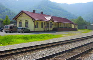
Matewan was the site of the May 1920 Matewan Massacre, which the town now occasionally re-enacts. The town of Matewan is now a National Historic Landmark, and walking tour brochures are available at the visitor’s center (www.matewan.com, or 304-426-4239). The visitor center museum has permanent exhibits on the feud, massacre, and coal mining history.
Mingo County has several outdoor recreational sites. The Twisted Run Golf Course is an 18-hole, PGA-style course on top of Horsepen Mountain in Wharncliff (304-664-9100). Laurel Lake Wildlife Management Area is northeast of Lenore and R. D. Bailey Lake and Dam, near Justice on the Mingo-Wyoming County line, is operated by the Army Corps of Engineers. Both offer fishing, hunting, hiking, and picnicking. Laurel Lake has a swimming pool. R.D. Bailey allows camping.
McDowell County, the southernmost county in West Virginia, was created in 1858. The McDowell County Courthouse in Welch, dating from the 1890s and a major site in the West Virginia Mine Wars, and the Welch Commercial Historic District are on the National Register of Historic Places. The Commercial District includes more than 50 buildings and the nation’s first municipal parking garage, opened in 1941.
Mining made McDowell County the center of the state’s black population. The first female black state legislator in the United States was Minnie Buckingham Harper from McDowell County who was appointed to the House of Delegates in 1928. Kimball has what may be the first and only remaining memorial honoring black soldiers who served during World War I. The Kimball War Memorial Building was dedicated in 1928, but a fire in 1991 left only a shell. The building has been restored and is once again being used as a community center. An exhibit called “Forgotten Legacy: Soldiers of the Coalfields” (www.forgottenlegacywwi.org) tells the story of blacks who migrated to McDowell County to work in the mines and later served in the war. The memorial building is open 9 a.m. to 1 p.m. Monday-Friday and by appointment.
Kimball also has a restored company store along U.S. Route 52, as does nearby Ashland, on County Route 17. The town of Coalwood, made famous by the book, The Rocket Boys, and the movie, October Sky, attracts tourists to take W.Va. 16 south from Welch.
McDowell County also has three wildlife management areas. Berwind Lake, Anawalt Lake, and Tug Fork. They all allow hunting, fishing, and picnicking. Anawalt does not allow camping while the others do. Panther State Forest in McDowell County has a swimming pool. By Jennifer Bundy
View See WV: Big Sandy and Tug Fork in a larger map