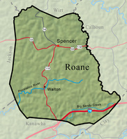
Roane County has an area of 484 square miles, its terrain hilly with narrow valleys. Ridges and hilltops rise to 1,000 feet, with some to 1,500 feet in the southeastern section. The principal streams are the Pocatalico River and Big Sandy Creek in the south, and several tributaries of the Little Kanawha River in the north. Wirt, Calhoun, Clay, Kanawha, and Jackson counties border Roane County.
U.S. 33 crosses Roane County east to west through Spencer; State Route 36 travels from Clay County north to Spencer; and State Route 14 goes north from Spencer to Wood County. U.S. 119 comes up from the south to intersect U.S. 33 at Spencer and then follows U.S. 33 eastward. Interstate 79 crosses the southern tip of the county.
Roane County was created by an act of the Virginia legislature on March 11, 1856, from parts of Kanawha, Jackson, and Gilmer counties. The new county was named for Judge Spencer Roane, a son-in-law of Patrick Henry. The citizens of the new county chose New California (later Spencer) as the county seat over Looneyville.
Jesse Hughes, the scout, hunter, and explorer, is reputed to have been the first person of European descent to enter the area, around 1770. He later settled in present Roane County, along with relatives such as the Gandees, Tanners, Bonnets, and Alkire-Holswades. Many residents of Roane County trace their ancestry to Hughes. The first settlers came in 1809. The families of John Kelly, Ware Long, and Francis Garner settled along Big Sandy Creek below the present community of Left Hand. Later John Ashley and his family arrived at the same site, thereafter known as Ashley’s Settlement. Spencer was first settled by the Samuel Tanner and Jonathan Wolfe families in 1812, with the Runnions arriving in 1818. Those first settlers lived in isolation until the 1830s when families such as the Goffs, Greathouses, Vandals, and Carpenters settled in the Spring Creek area.
Spencer and the other villages served the surrounding countryside with gristmills, general stores, tanneries, and other services. Spencer developed as the chief town after the construction of the Gilmer, Ripley & Ohio Turnpike and other roads in the 1850s and the town’s selection as the county seat. Reedy, the principal business center in the northern part of the county and the county’s other municipality, was established at the crossroads of the Ravenswood-Reedy Turnpike and the Reedy-Spencer Road.
Walton, on the Pocatalico River, is the principal community in the southern part of the county. Charles Droddy came to the area in the 1820s to buy furs and game, met Sarah Gandee, and married her before the end of the decade. They bought a large tract of land and started a gristmill, general store, and a boarding house. This area at the crossroads of two important trails became known as Droddyville or Droddy’s Mills. Meanwhile, the first post office in present Roane County, established around 1844, was located at a place named Walton, a few miles from present Walton. In 1856, the post office and the name were moved to Droddyville, which became Walton. Walton High School was established in 1923. It and Spencer High School were consolidated into a new Roane County High School in 1993.
Roane County depended on an agricultural economy centering on cattle and sheep. The number of farms rose from 834 in 1870 to 2,825 in 1900, while average farm size fell by two-thirds. During the same period the portion of the county’s land used for crops or pastures rose from 67 percent to 87 percent. Roads leading to river ports on the Ohio, Little Kanawha, and Elk rivers served as the main arteries for mail service and the import and export of goods. Major road and bridge improvements came in the 1870s and 1880s. A branch of the Baltimore & Ohio Railroad gave a major boost to the economy, especially the cattle and timber industries. It operated from 1892 until the early 1960s. During this time, too, was the beginning of the oil and gas industry, with drilling beginning around 1868. Spencer became an oil town in the early 1900s. Spencer State Hospital, originally known as the Second Hospital for the Insane, opened July 18, 1893, and employed many area residents until its closing in 1989.
In 2020, Roane County had a population of 14,028, a decline of 9.2 percent since the beginning of the 21st century. It is served by three banks and two weekly newspapers. Roane County Library has locations in Spencer, Walton, and Left Hand. There is one hospital, Roane General. The leading industries are petroleum, natural gas, and timber and its products. The chief agricultural products are hay and grain, livestock, dairying, and poultry.
As of 2022, its largest employers were, respectively, Roane General Hospital, the county school system, Walmart, Patch 21, and Armacell.
Spring Heights Education Center, a 1,000-acre United Methodist outdoor religious center, is located north of Spencer. Charles Fork Lake is the location of the annual Tour de Lake bike race, and during the second week of October Spencer hosts the Black Walnut Festival. Col. Ruby Bradley (1907–2002), decorated military nurse and war heroine, is among the notable Roane Countians.
This Article was written by David F. Matthews
Last Revised on January 19, 2023
Related Articles
Sources
Mylott, James P. A Measure of Prosperity: A History of Roane County. Charleston: Mountain State Press, 1984.
Comstock, Jim, ed. West Virginia Heritage Encyclopedia vol. 19. Richwood: Jim Comstock, 1976.
Cite This Article
Matthews, David F. "Roane County." e-WV: The West Virginia Encyclopedia. 19 January 2023. Web. 26 July 2024.


Comments?
There aren't any comments for this article yet.
Click here to read and contribute to the discussion →