

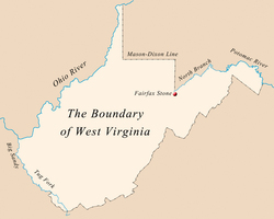
West Virginia’s boundary is about 1,170 miles long, with 52 percent marked by rivers and streams, 31 percent by watershed divides and crest lines, and 17 percent defined by latitude and longitude. The boundary encloses an area of 24,282 square miles. The most observable feature of shape are two panhandles: one of eight counties extending eastward for about 100 miles, and the other of four counties extending northward for about 65 miles.
According to Article II of the state constitution the northwestern boundary ‘‘includes the bed, bank, and shores of the Ohio River beginning at a point determined in 1779 by extending a line from the western end of the Mason-Dixon Line due north to the north bank of the Ohio River. From this point, just north of Chester, the state line runs downriver to Virginia Point at the mouth of Big Sandy River, a distance of about 277 miles. There are 12 border counties and 32 islands, including historic Blennerhassett Island and Wheeling Island, the most populated island in the Ohio River.
The southwestern boundary includes ‘‘so much of the . . . Big Sandy River as was formerly included in the Commonwealth of Virginia.’’ This boundary line begins in McDowell County at the confluence of Fourpole Creek with the Tug Fork of the Big Sandy and extends about 114 miles down the Tug and Big Sandy to the Ohio River at Virginia Point, near Kenova. This boundary was fixed when Kentucky and West Virginia became states in 1792 and 1863, respectively.
West Virginia’s most famous boundary is the Mason-Dixon Line, surveyed to settle a border shared at various points by Delaware, Maryland, (West) Virginia, and Pennsylvania. The better known east-west portion of the line was set at 39 degrees, 43 minutes, and 17.6 seconds, north latitude. In 1779, Virginia and Pennsylvania agreed that their boundary should be fixed as ‘‘that line commonly called Mason’s and Dixon’s line’’ extended due west five degrees of longitude from the Delaware River, and from that point another line was run northward to the north side of the Ohio River. These two straight lines define the square southwest corner of Pennsylvania, around which West Virginia wraps itself. The distances for these lines now dividing West Virginia and Pennsylvania are about 65 miles east-west, along the top of Preston, Monongalia, and part of Wetzel counties, and 55 miles south-north, up the eastern side of Marshall, Ohio, Brooke, and Hancock counties.
Virginia’s land and water boundaries with Maryland were passed to West Virginia in 1863. However, with about 40 square miles between Preston County, West Virginia, and Garrett County, Maryland, in dispute, a commission appointed by the U.S. Supreme Court in 1910 established the boundary between the two counties and their respective states. It was to begin on the south bank of the North Branch of the Potomac River north of the Fairfax Stone and to run north to the Mason-Dixon Line. The 36-mile boundary thus created appears almost straight and vertical on the map, but has five slight east-west breaks. Beginning where this line intercepts the North Branch, the Maryland-West Virginia line follows the south bank of the river for 218 miles to the boundary with Virginia, near Harpers Ferry.
West Virginia’s long eastern boundary, separating the old state from the new, follows the existing county lines separating 12 West Virginia counties and their Virginia neighbors. This boundary totals about 405 miles, running mostly along ridge tops. There have been boundary disputes between the two states: one involved Monroe, Giles, and Alleghany counties in 1956, and in 1997 the 16-mile boundary between Jefferson and Loudoun counties along the crest of the Blue Ridge was resolved by surveyors.
Rumors, legends, and tales abound about surveyors who missed the mark either because of whiskey, weather, terrain, or Indians, but the facts remain in their surveys that mark the boundary of West Virginia.
This Article was written by Howard G. Adkins
Last Revised on October 13, 2023
Related Articles
Sources
West Virginia Atlas & Gazetteer. Yarmouth, ME: Delorme, 1997.
Puetz, C. J. West Virginia County Maps. Lyndon Station, WI: Thomas Pub..
Van Zandt, Franklin K. "Boundaries of the United States and the Several States," Bulletin 1212. United States Geological Survey. United States Government Printing Office, 1976.
United States Geological Survey Maps, Scale 1:250,000. Baltimore, Bluefield, Canton, Charlottesville, Clarksburg, Cumberland, Huntington & Jenkins quadrangles.
Cite This Article
Adkins, Howard G. "The Boundary of West Virginia." e-WV: The West Virginia Encyclopedia. 13 October 2023. Web. 26 July 2024.
Comments?
There aren't any comments for this article yet.
Click here to read and contribute to the discussion →