 | Back to e-WV
| Back to e-WV
| Back to e-WV

Most of today’s motorists prefer to stick to the easier, far quicker driving offered by Interstate 64. But those travelers who are willing to take their time and instead drive the two-lane blacktop of West Virginia’s Midland Trail can get a glimpse into history that’s denied those who hurry along the super-highway.
The Midland Trail is more than a road, it’s a virtual history book. Originally a rude pathway worn by buffalo and the early pioneers, it stretches from White Sulphur Springs westward to Kenova, zigzagging along rivers, over mountains and through lush valleys. Along the way it touches just about every aspect and time period of West Virginia’s story: coal mines and chemical plants, Civil War battlefields and historic churches, and ancient Native American burial mounds. Over the decades, the Midland Trail has had many names. It’s been known as the Buffalo Trail, the Lewis Trail, the Old Virginia State Road, the James River & Kanawha Turnpike, the Midland Trail, and, ultimately, U.S. 60.
As it makes its way across West Virginia, the Midland Trail travels through six of the state’s 55 counties. In the east, the first of these is Greenbrier County. The Midland Trail then travels through Fayette, Kanawha, Putnam, Cabell and Wayne counties.
Getting there: Today the Midland Trail is U. S. Route 60, which closely parallels Interstate 64 from the Virginia line to the Sam Black Church exit and again from Charleston to the Kentucky line. It may be accessed at many points along these sections, and where it crosses U. S. 19 (Appalachian Corridor L) north of Fayetteville.
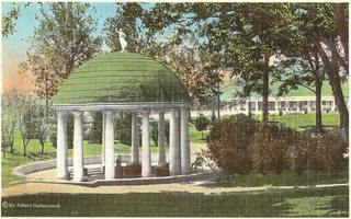
Weary travelers on the old James River & Kanawha Turnpike looked forward to stopping over at White Sulphur Springs to enjoy its mineral waters. In 1808, Michael Bowyer erected a tavern at White Sulphur, and his son-in-law, James Calwell, later added cottages and other amenities, including the resort’s first springhouse. The handsome springhouse shown on this postcard was built in the 1830s. Today the Greenbrier continues to welcome guests to a resort where history abounds at every turn.
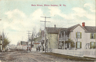
This vintage hand-colored postcard shows White Sulphur Springs as it appeared around 1900. The driver of the horse and buggy making its way down the dirt street soon would have to share the road with those new-fangled motorcars. Today, White Sulphur Springs lures visitors with its small-town charm and a variety of specialty shops and restaurants.

A few miles down the road from White Sulphur Springs is Lewisburg. The town was named for Andrew Lewis, who marched a force of Virginia militia to the Ohio River, where they narrowly defeated a group of Indians led by Cornstalk at the Battle of Point Pleasant in 1774. Today Lewisburg offers a comfortable mix of the past and present. Many buildings from the 18th and 19th centuries remain, tastefully updated and put to new uses as shops, offices, and restaurants.
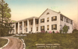
A familiar Lewisburg landmark, the General Lewis Inn, opened in 1929. The owners transformed an 1834 house into a hotel that celebrates the talents, handicrafts, and style of the region’s early settlers.
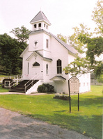
Sam Black Church is located on the Midland Trail at its junction with Interstate 64. A small bell tower rises above the hipped roof of the picturesque white frame structure. The church was erected in 1902 in memory of Samuel Black, a Methodist circuit rider. Mounted on his horse, Shiloh, Black traveled the back roads of a half-dozen West Virginia counties, organizing congregations and building churches with the money he obtained from selling socks, gloves, and other items handmade by church women.
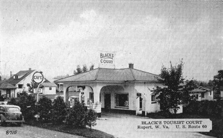
Before entrepreneur Kemmons Wilson built his first Holiday Inn in 1952 and revolutionized the lodging industry, travelers had to make do with roadside establishments that offered less-than-luxurious cabins. This postcard from Black’s Tourist Court, located on the Midland Trail at Rupert, boasted that it had “Private Baths, Toilets (and) Steam Heated Cabins,” and served plate lunches. Continuing its course to the west, the Midland Trail leaves Greenbrier County and heads into Fayette County. Created in 1831, the county was named in honor of the Marquis de Lafayette, who had played a key role in assisting the Continental Army during the American Revolution.
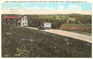
The caption on this vintage postcard, postmarked 1934, shows the summit of Sewell Mountain on the Midland Trail and describes it as “near Charleston, W.Va.,” although in fact Charleston lies roughly 50 miles to the west. In 1861, Union and Confederate forces both bivouacked on the mountain, though no battle erupted there. It was here that General Robert E. Lee first saw his treasured horse, Traveller, later purchased by Lee for $200 in Confederate currency.
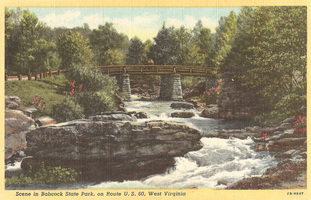
The entrance to Babcock State Park is at the Midland Trail’s intersection with State Route 41. The park offers its visitors 4,127 acres of serene yet rugged beauty, a fast-flowing trout stream in a boulder-strewn canyon, and mountain vistas to be viewed from several scenic overlooks. The park, which opened in 1937, was built as a Depression-era public works project, with the main facilities and trails constructed by the young workers of the Civilian Conservation Corps.
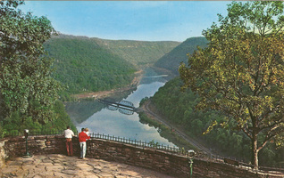
Hawks Nest, the site of Hawks Nest State Park, is a peak on Gauley Mountain near Ansted overlooking the New River Gorge. The cliffs rise above the New River, providing a breathtaking view of the river and the wooded hillsides below. John Marshall, chief justice of the U.S. Supreme Court, visited the area in 1812, and for a time the cliffs were known as Marshall’s Pillars. When the James River & Kanawha Turnpike was constructed in the 1820s, the rocky formation overlooking the gorge became a popular stopping place for travelers. Hawks Nest gets its name from the hawks that ride the thermals between the high cliffs.
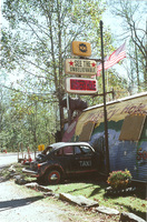
Located not far from Hawks Nest, the Mystery Hole is hard to miss. This attraction features a statue of a gorilla on the roof and a Volkswagen Beetle that appears to have crashed into its side. The Mystery Hole opened in 1973 and has been a favorite of travelers ever since.
The unincorporated community of Chimney Corner is located at the intersection of the Midland Trail and State Route 16. Over the years, it has been home to everything from a speakeasy to a gas station. Today it is home to the Country Store, specializing in handmade crafts and old-time candies and sodas. The store also features an appealing front porch.
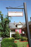
Glen Ferris was known until 1895 as Stockton, for Colonel Aaron Stockton, who settled in the area in 1812. During the early days of the James River & Kanawha Turnpike, Stockton kept a popular tavern where travelers could get food, drink and a bed for the night. The last stagecoach rolled along the turnpike in 1873, but even so Stockton’s tavern survived, and in 1929 was converted into the popular Glen Ferris Inn, which still welcomes guests. As it enters Kanawha County from Fayette County, the Midland Trail hugs the northern bank of the Kanawha River.
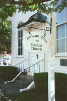
The Kanawha County community of Malden, originally called Terra Salis and later known as Kanawha Salines, was the center of an extensive salt industry from roughly 1800 until the Civil War. Today, the little town is best known as the boyhood home of Booker T. Washington, who rose from slavery to become one of the nation’s great leaders. Malden is home to the African Zion Baptist Church, founded in 1852, where Washington taught Sunday School. A replica of his boyhood cabin has been erected near the church.
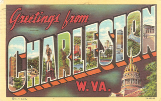
Charleston, West Virginia’s capital and its largest city, is situated on the Kanawha River at the mouth of the Elk River. The first settlers arrived in 1788 and built what was known as Fort Lee near the present downtown. Their leader was George Clendenin, and in 1894 the Virginia General Assembly chartered a town known as Charlestown, named for Clendenin’s father, Charles. Later the name would be shortened to Charleston.
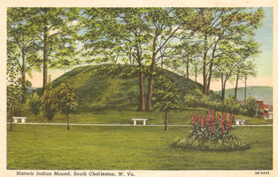
South Charleston is the site of the second-largest remaining Indian burial mound in West Virginia. The South Charleston, or Criel, Mound was deeded to the city in 1931 for use as a public park.
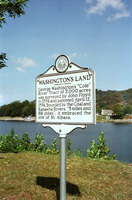
The Midland Trail runs along the riverbank through the town of St. Albans. A roadside marker notes that George Washington owned land along the Kanawha and Coal rivers, a tract that included the present site of downtown St. Albans.
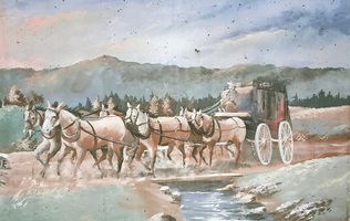
Hurricane Bridge, shown on maps of Virginia as early as 1811, was located about one mile north of the present Putnam County community of Hurricane. The James River & Kanawha Turnpike crossed the creek, but it was too deep for the stagecoach and other conveyances to ford, so a sturdy bridge was built. A small community grew up near the bridge. This painting of a stagecoach making its way to Hurricane Bridge is one of a half-dozen colorful murals that decorate buildings in downtown Hurricane.
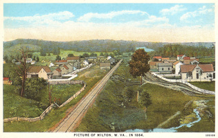
An early settlement grew up at the Mud River crossing of the James River & Kanawha Turnpike. When the Cabell County town was incorporated in 1876, it was named for Milton Rece, a large landowner and Milton’s first postmaster. Over the years it developed as a regional commercial and small-scale industrial center. Local residents sometimes describe themselves as being from “Milton on the Mud,” a reference to the Mud River that regularly spills out of its banks and sends folks heading for higher ground. This postcard reproduces a picture of Milton dated 1884.
Barboursville, located near the junction of the Mud and Guyandotte rivers, was founded in 1813 and named for James Barbour, who was governor of Virginia at the time. In 1835, a visitor described it as a “handsome little village.” In its early years, the village was home to small factories and other businesses. The James River & Kanawha Turnpike ran straight through the little town. A side road connected the turnpike to the nearby village of Guyandotte.
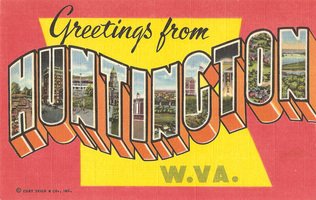
The citizens of Guyandotte were sure that Collis P. Huntington would select their little village as the western terminus of his Chesapeake & Ohio Railway. Instead, Huntington purchased a tract of level land on the Ohio River just downstream from Guyandotte and there set about building an entirely new town. An early visitor to Huntington reported finding eight churches, four hotels and “a generous number of saloons.” Today Huntington is a regional center for health care and is home to Marshall University.
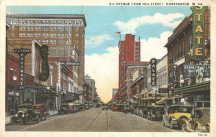
This postcard shows Huntington’s Fourth Avenue as it would have appeared to a visiting traveler in the late 1920s or early 1930s. The tall building at the left is the former First Huntington National Bank Building. The tall building in the center of the card is the West Virginia Building, at one time the tallest in the state.
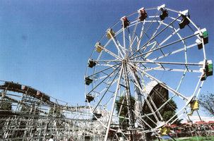
Just west of Huntington on U.S. 60 is Camden Park, a West Virginia landmark that’s been attracting fun seekers for more than a century. Camden Interstate Railway, which operated a streetcar line that connected Huntington and Ashland, opened the park in 1903 and named it for the line’s principal investor, Senator Johnson Newlon Camden of Parkersburg. Camden Park was one of hundreds of similar amusement parks across the country created to bolster the number of passengers who rode trolleys, especially on weekends. Camden Park is one of only a handful of the original trolley parks still operating and is the state’s only amusement park.
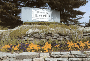
Just to the west of Camden Park, the Midland Trail enters the little town of Ceredo where the members of the Ceredo Beautification Committee work on projects such as this welcome sign that greets motorists. As you head west along the Midland Trail you leave Ceredo behind and drive directly into Kenova. Only the locals can tell you where one town stops and the other begins. Most folks in the Huntington area tend to talk about “Ceredo-Kenova” as if it were one place.
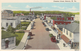
Kenova is the largest community in highly rural Wayne County. Its history was shaped in large measure by its location on the Ohio and Big Sandy rivers where Kentucky, Ohio and West Virginia meet. Its name sounds like the name of an Indian tribe, but it was devised by taking a few letters from each of the three states’ names. Kenova once served as a shipping port for timber floated down the Big Sandy River from the wooded slopes to the south. Given Kenova’s forest heritage, it’s surely not coincidental that many of the city’s streets are named for trees. The Midland Trail makes its way along Oak Street. Other Kenova street names include Beech, Walnut, Poplar, and Chestnut. This heavily retouched postcard view offers a glimpse of Kenova’s Chestnut Street as it looked in the 1940s.
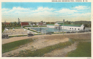
Dreamland Pool is surely Kenova’s best-known landmark. Built on the Big Sandy riverbank in 1925, it’s been attracting summer fun-seekers ever since. Dreamland added a dance pavilion to the roof of its main building in the 1930s. The pavilion (shown at the upper right of this postcard view) quickly became a popular nightspot, attracting crowds to dances featuring musical stars such as Glenn Miller, Benny Goodman, and Louis Armstrong, as well as a host of local talent. The building housing the pavilion burned in 1973, while the city of Kenova was negotiating to purchase the pool from its private owners. The deal went through anyway, and the city has operated the pool each summer since 1974. Dreamland is the Midland Trail’s last stop on its 172-mile trip through West Virginia. Once it passes Dreamland, the historic roadway crosses the Big Sandy and heads into Kentucky.
All images are reprinted, with permission, from Highway to History: A Midland Trail Scrapbook (Quarrier Press, $17.95) by James E. Casto, the author of a number of books on local and regional history.