| Back to e-WV
| Back to e-WV
| Back to e-WV
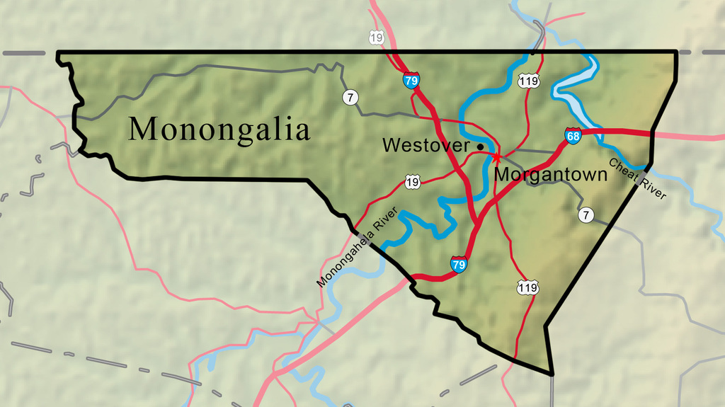


In July 1775, Virginia formed the District of West Augusta on the western frontier. In October 1776, West Augusta was subdivided into three large counties, Monongalia, Yohogania, and Ohio. Since that time many counties in Pennsylvania and present West Virginia have been formed from the original Monongalia County.
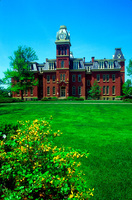
Morgantown, the county seat of Monongalia County, is a regional financial, educational, commercial, and medical center. It is home to West Virginia University, the largest college in the state. The Morgantown home of reformer Alexander Luark Wade is a National Historic Landmark.Morgantown is also home to the Core Arboretum and the historic Metropolitan Theater.
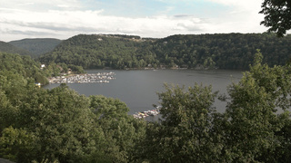
The Cheat River drains about 1,420 square miles in northern West Virginia. It flows free, untamed, and without dams from its headwaters to Cheat Lake.
The Monongahela River is formed at Fairmont by the merging of the West Fork and Tygart Valley River. The ‘‘Mon,’’ as it is often called by people of the region, terminates 128 miles away at Pittsburgh, where it joins the larger Allegheny to form the Ohio River.
The Cheat River dam was built as a privately owned hydroelectric facility in 1924–26. The resulting Cheat Lake covers 1,730 surface acres, stretching from the Mason-Dixon Line across the northeastern corner of Monongalia County. The lake is 13 miles long and from one to three miles wide.
Originally farmland, Westover was settled as a suburb of Morgantown at about the turn of the 20th century, attracting families to its good school and large country-style building lots. Many early residents kept a garden, fruit trees, poultry, and livestock.
The area of West Virginia known as the Forks of Cheat lies between the Monongahela and Cheat rivers, including Stewartstown and the surrounding area in the northeast corner of Monongalia County and neighboring Pennsylvania. Forks of Cheat is home to the historic Forks-of-Cheat Baptist Church (1775).
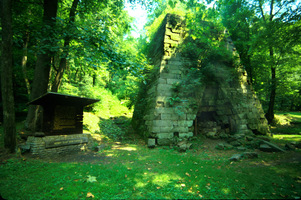
Coopers Rock State Forest is named for Coopers Rock, a series of cliffs capping the mountain above Cheat River Gorge. The forest is home to the Henry Clay Furnace, a cold blast iron furnace that was built about 1836.
Easton Roller Mill, a landmark industrial site, is located at Easton. Maryland entrepreneur Henry Koontz bought a 600-acre farm there in 1859. Construction of the mill began in 1864, during the Civil War, and the mill was in operation by 1867.
West Virginia University was founded February 7, 1867, as a federal land-grant institution under the Morrill Act, which Congress passed in 1862 to support agricultural colleges in each of the states through grants of public lands located mostly in the West and Midwest. Originally the university was called the Agricultural College of West Virginia.