 | Back to e-WV
| Back to e-WV
| Back to e-WV
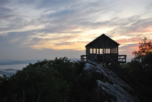
The Jefferson National Forest, primarily located in southwest Virginia, was established by President Roosevelt on April 21, 1936. The Jefferson is about 720,000 acres in size and is situated in the Ridge and Valley Physiographic Province including the Allegheny and Blue Ridge mountains. Jefferson National Forest lands stretch from Rockbridge County, Virginia, west into Letcher and Pike counties, Kentucky, and from Washington and Grayson counties, Virginia, north to Monroe County. The West Virginia portion of this forest contains 19,187 acres in Monroe County (about 2.64 percent of its total area) and is part of the New River Valley and New Castle Ranger Districts, accessible by State Routes 15, 17, and 20. Oak-pine forests cover the mountainous West Virginia forest lands, which range in elevation from 2,000 to 3,600 feet.
The Jefferson, along with all other national forests, is administered by the Forest Service, U.S. Department of Agriculture. The forest supervisor, located in Roanoke, Virginia, administers both the Jefferson and George Washington national forests. The early management focus was primarily aimed toward protection, with fire prevention in the slash-filled cut-over woods as a major concern. Forest lands have recovered since that time, and present policy is to manage for multiple resources including wood, water, wildlife, recreation, and livestock forage. A portion of the congressionally designated Mountain Lake Wilderness is situated in Monroe County, including parts of Potts and Little mountains. All caves and abandoned mines in the forest were closed in 2010, in an effort to control the spread of white-nose disease among bats.
Written by Walter A. Lesser
Sarvis, Will. History of the Jefferson National Forest. U.S. Forest Service, Roanoke, VA, 1992