 | Back to e-WV
| Back to e-WV
| Back to e-WV
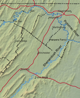
The Shenandoah River and its main tributaries flow northeastward for almost 150 miles, chiefly through the Shenandoah Valley in Virginia between the Blue Ridge and the Allegheny mountains. The two forks of Shenandoah meet at Front Royal, Virginia, and from there the Shenandoah mainstream continues for 55 more miles, joining the Potomac River at Harpers Ferry. The final stretch of the Shenandoah flows through Jefferson County, West Virginia. The Shenandoah has a 3,000-square-mile drainage area, which includes a large portion of Virginia west of the Blue Ridge and much of Jefferson County.
The word ‘‘Shenandoah’’ is of Indian origin, and its meaning is a matter of dispute. The most popular interpretation is ‘‘Daughter of the Stars.’’ Areas along the North and South forks of the river near Front Royal have yielded the first evidence of inhabited structures in North America, dating to 9300 B.C. Native Americans began farming along the Shenandoah about A.D. 900.
The valley was explored by John Lederer, a German doctor, in 1669. Lederer crossed the Blue Ridge near Swift Run Gap in present Madison County, Virginia, and took detailed notes of the wildlife, terrain, and several Indian tribes he encountered. In the early 18th century, Lord Fairfax Fairfax, an Englishman, inherited a large part of the northern valley. Young George Washington surveyed parts of Fairfax’s estate, including lands now part of the Eastern Panhandle of West Virginia.
Called the breadbasket of the Confederacy, the Shenandoah Valley was an important military objective during the Civil War. Gen. Thomas ‘‘Stonewall’’ Jackson made his reputation defending the valley against federal troops early in the war.
One of the first recorded floods of the Shenandoah took place in the fall of 1753 and was called the “Pumpkin Flood.” The swollen river picked up pumpkins from Indian gardens and sent them downstream. The worst flood took place on October 16, 1942, after remnants of a tropical storm brought heavy rain to the state. The river at Millville crested at 32.4 feet, nearly 19 feet above flood stage. Other major floods took place in 1852, 1870, 1896, 1936, 1972, 1985, and 1996.
In 1945, West Virginia author Julia Davis published The Shenandoah, part of the Rivers of America series. Davis told the history of the valley and the river, drawing on her own research and the experiences of ancestors who settled and lived in the area. Still in print more than a half-century later, her book provides a poetic vision of both the river and the valley. ‘‘More than history, the Valley is a way of life,’’ Davis wrote. ‘‘It is the rich fields, and the mountains older than measured time. It is the stillness of the hot noon, or of moonlight, or of snow. It is the calm old houses, where the oak leaves and the doves have time to set up their music in the heart of a child.’’
Written by William D. Theriault
Davis, Julia. The Shenandoah. New York: Farrar & Rinehart, 1945.
Strother, David Hunter. Artists' Excursion Over the Baltimore & Ohio Rail Road. Harper, (June 1859).