 | Back to e-WV
| Back to e-WV
| Back to e-WV
The first overland routes in Western Virginia evolved from Indian and game trails that followed the prevailing ridges and valleys. Many of these trails formed the basis of an extensive system of turnpikes that spanned present West Virginia before the Civil War. In the late 19th century, new highway construction slowed and many established routes either devolved into local haul roads or were abandoned amid competition from the railroads.
A call to repair the state’s highway system came in the 1890s, when dedicated bicyclists allied themselves with farmers who needed decent roads to carry their produce to market. At the time, responsibility for road construction fell to the counties, and local officials concentrated on building roads to their own county seat rather than from one county to another.
With the dawn of the automobile era came a statewide Good Roads Movement, which sought ‘‘to pull West Virginia out of the mud.’’ Still, by 1909, 1,200 miles of paved highways connected only two county seats. Characterized by tight curves, high accident rates, and long driving times, many of these routes were rightly regarded as dangerous. Few travelers ventured beyond their own locality.
West Virginia launched a series of highway improvements beginning in 1917 with the creation of the State Road Commission, whose duties included building, maintaining, and classifying public roads, providing for a statewide system of connecting highways, and coordinating revenue-raising efforts. The agency also furnished information for the location, construction, and maintenance of inter-county or other main routes called Class A roads, which typically extended border to border within a county on an east-west or north-south orientation.
In 1920, a Good Roads Amendment consolidated 4,600 miles of country roads into a state highway system. In 1922, east-west routes were assigned odd numbers and north-south routes received even numbers. The first sequentially numbered routes (1 through 4) were intended to be the main statewide thoroughfares. Routes were marked on roadside utility poles, with the original road markers consisting of two red bands six inches wide, separated by a 12-inch white strip upon which the route number was stenciled in six-inch figures. The National Road through Ohio County (originally State Route 29, now U.S. 40) used the same red, white, and blue markers as it did in Pennsylvania and Ohio.
The Federal Highway Act of 1921 directed each state to recommend for federal designation a connected road system. Funds were now available for a Federal Aid highway system of primary and secondary roads which in West Virginia totaled nearly 2,000 miles. These ‘‘FA’’ routes received separate designation independent of state roads, although a number of state road miles were included and thus became eligible for federal funds. The highway act further encouraged states to build connector routes that were ‘‘interstate in character,’’ a move that led to the establishment of a separate state road system controlled by the State Road Commission.
In late 1925, a federal board unveiled a national system of interstate routes and a uniform highway sign. Original federal routes in West Virginia included U.S. 11, U.S. 19 (replacing State Route 4), old U.S. 21, U.S. 40 (the National Road), U.S. 50 (replacing State Route 1, the old Northwestern Turnpike), and U.S. 60 (replacing portions of State Route 3, the Midland Trail). These roads still serve us today, with upgrading and some relocation of routes. U.S. highway numbers were erected on metal shield markers bearing the letters ‘‘W. Va.’’ at the top, with ‘‘U.S.’’ and the route number below in black letters and figures on white.
By the 1920s, interest in transcontinental highways brought about a number of ‘‘national trail’’ associations that incorporated historic turnpike alignments. Among those later included into the federal highway system were the National Old Trails Road that followed the National Road (U.S. 40), the George Washington Highway that shadowed the Northwestern Turnpike (U.S. 50), and the Midland Trail on the James River & Kanawha Turnpike alignment (U.S. 60).
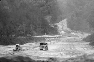
The pace of highway development increased statewide in the 1930s and ’40s. A 1933 legislative act brought every public road in West Virginia under direct state control. This law designated more than 4,400 miles of roads as primary state highways, and reclassified some 31,000 miles of county roads as secondary state highways. Next came the Federal-Aid Highway Act of 1944, which authorized designation of a ‘‘National System of Interstate Highways’’ that would connect principal metropolitan areas and industrial centers and serve the national defense. In 1947, the legislature appropriated funds for the West Virginia Turnpike, the state’s modern, long-distance, multi-lane ‘‘superhighway.’’ Completion of the 88-mile turnpike from Princeton to Charleston came in 1954 at a cost of $133 million, to be funded through the sale of bonds paid from tolls.
Highway development reached new levels with passage of the Federal-Aid Highway Act of 1956 that designated the 46,000-mile National System of Interstate and Defense Highways, also known as the Eisenhower Interstate System. These are the ‘‘interstates’’ we know today, modern high-speed, controlledaccess highways of four lanes or more. Interstate highway construction in West Virginia proved costly and difficult and completion of the final sections did not occur until the late 1980s. Currently, the state has 549 miles of interstate highways; east-west routes include I-64, I-68, I-70, and I-470, while I-77, I-79, and I-81 run north to south.
In the 1960s, the Appalachian Regional Commission proposed more than 3,000 miles of modern roads in a system of 26 highway corridors to foster economic and social development throughout the 13- state Appalachian Region. By 1995, a quarter of all ARC highway funds had gone to West Virginia for six of the program’s most expensive roads. Identified as Corridors D, E, G, H, L, and Q, these routes traverse some of the most rugged regions of the state. Most of West Virginia’s corridor highways were complete by the 1990s, and only the controversial Corridor H remained unfinished by 2023.
In 1969, the West Virginia Division of Highways (DOH) supplanted the State Road Commission. It is now part of the state Department of Transportation, which employs more than 6,000 people across the department including 4,800 with the DOH. The department’s other agencies are the Division of Motor Vehicles; Division of Public Transit; Public Port Authority; Parkways, Economic Development and Tourism Authority (West Virginia Turnpike); State Rail Authority; and Aeronautics Commission.
The DOH is responsible for the planning, engineering, construction, and maintenance of some 39,000 miles of state highways, 3,200 miles of municipal roads, 555 miles of interstate highways, 1,988 miles of national highways, 7,000 bridges, five national byways, 14 state scenic byways, eight backways, and one All-American Road: the National Road. Also, the DOH sponsors a variety of programs to improve the driving experience and beautify state roads, including the Adopt-a-Highway program.
Written by Billy Joe Peyton