 | Back to e-WV
| Back to e-WV
| Back to e-WV
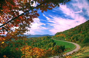
Beginning at Richwood and extending to a point near Marlinton, the Highland Scenic Highway provides access to the high mountains at the headwaters of the Cranberry and Williams rivers. The first section of the road is along the North Fork of the Cherry River on State Route 39. After climbing to almost 4,000 feet on Kennison Mountain, the scenic highway leaves State Route 39 on Cranberry Mountain. It continues as State Route 150 along the top of Black Mountain, gaining an altitude of over 4,500 feet. Following a descent for the crossing of the Williams River, the highway climbs back to 4,300 feet on Tea Creek and Red Lick mountains before a junction with U.S. 219 on Elk Mountain.
Construction of the 22 miles of State Route 150, which was built specifically for the scenic highway, began in 1965 at the Cranberry Visitors Center and was completed in 1981. This section was dedicated on October 11, 1981. Today’s Highland Scenic Highway is the completed portion of an originally envisioned scenic road extending from the southern end to the northern end of the Monongahela National Forest. Planned extensions to U.S. 250 in Randolph County and even to U.S. 50 in Grant County were never built. The Highland Scenic Highway was designated a National Scenic Byway in 1996.
Written by William P. McNeel