 | Back to e-WV
| Back to e-WV
| Back to e-WV
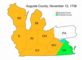
Named for Augusta, Princess of Wales, Augusta County was created November 12, 1738. Frederick County, named for Augusta’s husband, the Prince of Wales, was created by the same act, which stipulated that both counties were created from the western lands of Orange County.
The county government of Augusta County was organized in 1745. The western boundary of Augusta was defined as ‘‘the utmost limits of Virginia,’’ which meant the Mississippi River in the west and the headwaters of the Mississippi in the northwest. From Augusta County whole states would be carved, including Kentucky, Ohio, Indiana, Illinois, Michigan, and Wisconsin, as well as the southwest corner of Pennsylvania and most of West Virginia.
In 1732, John Lewis settled near the present site of Staunton and built a dwelling that also incorporated a fort, which became Fort Lewis. By the 1750s traders were active in the Ohio Valley sector of Augusta County. In 1754, during the French and Indian War, the governor of Virginia established a fort on the present site of Pittsburgh and offered land to those who would enlist to fight. In 1758 the fort was named Fort Pitt. The jurisdiction of the Augusta County court was extended, and additional justices were appointed to meet at Fort Pitt. Land grants in the area were recorded in the county courthouse in Staunton. Pennsylvania also claimed the area around Fort Pitt and created its own county of Westmoreland, which caused friction between the two colonies.
Despite the Royal Proclamation of 1763, which followed the French and Indian War and prohibited settlement beyond the Appalachian divide, people moved into western Augusta County and encountered various tribes of Indians. To alleviate hostilities the government negotiated treaties with the Indians. By the Treaty of Hard Labor in 1768 the Cherokees gave up claims to land in western Augusta that is in present West Virginia. That same year under the Treaty of Fort Stanwix the Iroquois and other tribes relinquished all claims to land lying west of the Alleghenies between the Ohio and Tennessee rivers. This included a separate agreement of some 2,862 square miles north of Little Kanawha River and west of the Monongahela River, known as Indiana Territory and including present northwestern West Virginia. This area was the subject of land development schemes variously called Grand Ohio Company, Vandalia Company, and Walpole Company organized in the spring of 1769. Claiming the Trans-Allegheny region on the basis of its charter of 1609, the Indian treaties, and possession, Virginia successfully defended its rights to the territory. Nonetheless Indian resistance continued into the 1790s.
The District of West Augusta was created in 1776, and the same year some inhabitants of that district petitioned the Continental Congress to establish a separate state called Westsylvania. On October 7, 1776, the District of West Augusta was divided into three new Virginia counties: Yohogania, Ohio, and Monongalia, and the Westsylvania proposal lost support. In 1779 commissioners from Virginia and Pennsylvania met to settle the boundary between the two colonies. Pittsburgh and the surrounding area were ceded to Pennsylvania. The small portion of Yohogania County that remained in Virginia was added to Ohio County. Yohogania became extinct.
Botetourt County had been formed from the southern half of Augusta County in 1770, and two years later Fincastle County was created from western Botetourt. Effective January 1, 1777, Fincastle County became extinct, and the counties of Kentucky, Washington, and Montgomery were created from the same area. Plans to establish a new state of Franklin to include land that had been part of southwestern Augusta in present east Tennessee and surrounding areas, including parts of southern West Virginia, were defeated when Virginia let it be known that it would not approve. Kentucky County was divided into three counties (Fayette, Jefferson, and Lincoln) in 1780, and six additional counties were organized before the territory originally known as Kentucky County became the state of Kentucky with Virginia’s blessing in 1792.
Meanwhile, George Rogers Clark had led a successful military expedition into the Illinois territory, and Illinois County was formed from Augusta County in 1778. In 1784, Virginia ceded its claim to the Northwest Territory including Illinois County. That territory became the states of Ohio, Indiana, Illinois, Wisconsin, and Michigan. By the acts of cession of 1784 and 1792, Virginia trimmed its western boundary to the Ohio River, thus reducing its size to the present territory of Virginia and West Virginia. Also, by 1792 all that remained of the original Augusta County was 968 square miles situated between the Blue Ridge and Allegheny mountains. Today, its boundaries unchanged since 1791, Augusta County is a thriving agricultural community with a diverse economic base and its county seat still at Staunton.
Written by Louis H. Manarin
Peyton, John Lewis. History of Augusta County, Virginia. Staunton: S. M. Yost & Son, 1882.
Robinson, Morgan P. Virginia Counties: Those Resulting from Virginia Legislation. Richmond: Superintendent of Public Printing, 1916.
Waddell, Joseph Addison. Annals of Augusta County. Staunton: C. Russell Caldwell Pub., 1902.