 | Back to e-WV
| Back to e-WV
| Back to e-WV
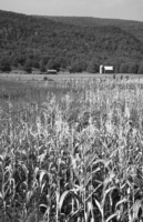
With an area of 584.6 square miles, Hardy County is divided by South Branch Mountain. Four rivers penetrate its boundaries. On the west lies the South Branch of the Potomac, which is joined by the South Fork at Moorefield and flows north from there through the Trough and into neighboring Hampshire County. On the east is the Lost River, which disappears under Sandy Ridge and comes out as the Cacapon River. The rivers all flow north and eventually join the main Potomac River. Located in the Eastern Panhandle, Hardy County is bounded by Virginia on the east, Hampshire County on the north, Grant County on the west, and Pendleton County on the south.
Formed in 1786, Hardy County had been part of Hampshire County. The county was named for Samuel Hardy, a member of the Virginia state legislature, lieutenant governor, and a delegate to the Continental Congress. Eighty years later, Grant County broke away from Hardy in 1866. There are two incorporated towns: Moorefield, the county seat, formed in 1777, and Wardensville in the Capon Valley, chartered in 1832 and named for Jacob Warden. In 2020, Hardy County had a population of 14,299, the most in its history and nearly double its total from 1970.
Hardy County was described as a borderland by historian Alvin E. Moore, who said the county was one of the last frontiers before settlers began crossing the Alleghenies, and then again during the conflict between North and South.
The Shawnees left cleared land in the Indian Old Fields. Early settlers were predominantly Scotch-Irish, German, English, and Dutch. They cleared land and built homes on disputed holdings of Virginia’s so-called Northern Neck, those lands claimed by both Lord Fairfax and by the colony of Virginia. In 1748, Fairfax sent a survey party to the South Branch Manor. In that group was 16-year-old George Washington, who left an account of the Trough and other experiences of the trip in his journal.
The area saw bloodshed between the Indians and settlers, between the Tories and patriots of the Revolution, and during the Civil War. Besides providing men to fight, Hardy County was an important source of livestock and grain, helping to support the armies in all these conflicts.
Hardy County was divided in its allegiances during the Civil War, with those favoring the Union splitting off to form Grant County soon afterwards. Southern sympathizers joined McNeill’s Rangers, a guerrilla band formed by Capt. John Hanson McNeill. Toward the end of the war, in their most daring raid, the Rangers, then led by McNeill’s son, Jesse, captured two Union generals, George Crook and Benjamin Kelley, from among thousands of federal troops garrisoned in Cumberland, Maryland. They spirited the generals south to Richmond while being chased by embarrassed federal troops.
Hardy County has a portion of the George Washington National Forest within its boundaries, as well as Lost River State Park, which was constructed by the Civilian Conservation Corps in the late 1930s. The park is also the location of the Lee Sulphur Spring, one of the early spas, where the family of Robert E. Lee’s father, Lighthorse Harry Lee, built a cabin and partook of the waters. The Lee cabin is still standing. Trout Pond, located in the National Forest, is West Virginia’s only natural lake, although only two acres in size. An added attraction is Rock Cliff Lake, a 17-acre man-made lake in the same area. Canoe and kayak enthusiasts enjoy going through the Trough on the South Branch. This natural cut in the mountains is also home to bald eagles. The river offers trout and bass fishing. The South Branch Valley Railroad, a state-owned railroad, was purchased from the Baltimore & Ohio Railroad to supply the multi-million dollar poultry industry with grain, and is headquartered in Moorefield.
Hardy County is also home to Eastern West Virginia Community & Technical College.
Beginning in 1877, Hardy County, in particular, Moorefield, was hard hit by a series of floods. Record floods came in 1912, 1924, 1936, and 1949, the worst of these being the 1949 flood. On June 18, 1949, the river at Moorefield crested at 16.10 feet, more than six feet above flood stage. The most devastating flood the county’s history hit on November 4-5, 1985, tearing away bridges, roads, railroads, homes, businesses, and people’s lives. During that flood the river reached 19.99 feet, more than nine feet above flood stage.
A series of flood prevention dams were built on the South Fork starting in the 1960s, and then on the Lost River watershed in the 1990s. In the mid-1990s, work began on a levee around Moorefield. Before it was completed, two more floods hit in 1996.
Transportation to and within the county has changed significantly with construction of Corridor H, a four-lane east-west road that eventually will connect Hardy to the central part of the state on the west and to Virginia on the east. By 2020, the highway was open from Davis through Moorefield to about seven miles west of Wardensville. The segment from Wardensville to the Virginia state line is not expected to begin construction until 2027. The road has made travel to and through Hardy County more convenient while bringing up new challenges in terms of planning and zoning regulations, historic preservation, quality of life, and environmental concerns.
As of 2022, Hardy’s largest employers were, respectively, Pilgrim’s Pride, American Woodmark, the county school system, Walmart, and Summit Community Bank.
Written by Phoebe Heishman
MacMaster, Richard K. The History of Hardy County 1786-1986. Moorefield: Hardy County Public Library, 1986.
Moore, Alvin E. History of Hardy County of the Borderland. Parsons: McClain, 1963.
Duffey, J. W. Two Generals Kidnapped, Booklet. Moorefield: Moorefield Examiner, 1944.