 | Back to e-WV
| Back to e-WV
| Back to e-WV
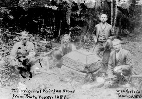
The Fairfax Stone, which originally marked the western extent of the Fairfax estate, is an important West Virginia landmark. The estate, one of Virginia’s largest colonial land grants, included most of the present Eastern Panhandle. The Fairfax lands extended to the headwaters of the Potomac River, and the setting of the stone in 1746 at the source of the Potomac North Branch helped to establish the North Branch as the river’s main stem. The Fairfax Stone also marked the boundary between Maryland and Virginia, now West Virginia, at the westernmost end of Maryland.
The marker was significant in property disputes until 1912, when the U.S. Supreme Court confirmed the North Branch as the Potomac main stream, and a new concrete marker was placed. The current Fairfax Stone, the fifth, was dedicated as a state historic monument and became part of the West Virginia State Park system in 1957 when the Western Maryland Railroad gave four acres of land surrounding the stone to the state. The Fairfax Stone site was added to the National Register of Historic Places in 1970. The Fairfax Stone stands at the junction of Tucker, Grant, and Preston counties.
Read the National Register nomination.
Written by Patricia Hissom
Morrison, Charles. The Fairfax Line. Parsons: McClain, 1970.
Fansler, Homer Floyd. History of Tucker County. Parsons: McClain, 1962.
Morrison, Charles. The Western Boundary of Maryland. Parsons: McClain, 1976.
United States Geological Survey Maps,