 | Back to e-WV
| Back to e-WV
| Back to e-WV
Floods develop when the volume of water supplied to a stream exceeds the capacity of the stream’s channel. In natural settings, rainfall runoff from hill slopes and mountainsides supplies most floodwater, with direct precipitation into streams and groundwater flow contributing minor amounts. Melting snow may contribute to West Virginia floods from late autumn to early spring.
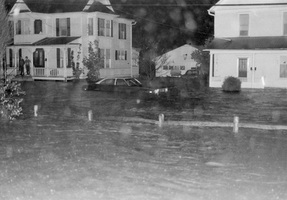
Flooding begins when flow reaches the top of a stream’s banks and spreads over the nearby floodplain. Most large streams have broad low-lying floodplains that provide temporary storage of floodwater and reduce the flow. In contrast, floodplains may be small or missing altogether along steep mountain streams or on large streams flowing through narrow gorges. These streams are characterized by ‘‘flash floods,’’ with little or no warning and extremely fast flows that may exceed 10 miles per hour.
Floods are natural events. They produce commonly overlooked benefits, including the bottomlands that make up most of the flat terrain in many parts of the Mountain State. The decrease in velocity when floodwaters leave their channels and spread onto bottomlands causes sand and silt to settle out and create rich alluvial soils. Floods also create the basic ecological structure of streams and bottomlands. Indeed, to understand the nature of any stream, one must first study the nature of its formative flood events.
Unfortunately, human intervention frequently leads to disastrous consequences. People often overlook the fact that floodplains are parts of rivers and are unprepared for the inevitable occasions when rivers exert their authority over their entire domain. It is human nature to blame the stream for causing damage, when in fact the real culprit may be decades of unwise floodplain development.
Floods are triggered by a complex variety of events. Dam or levee failures represent the most dangerous source. The Mountain State’s most deadly flood, caused by the failure of poorly designed coal-refuse dams on Buffalo Creek in Logan County on February 26, 1972, reached approximately 50,000 cubic feet per second near Saunders. The Buffalo Creek flood left 125 dead and 4,000 homeless.
There is a strong relationship between the size of the drainage basin and the type of precipitation that yields flooding. Small-stream floods commonly are triggered by short-lived local rainfall, such as intense late-spring or summer thunderstorms. Many of the record flows on small streams in West Virginia were isolated events, occurring when no other streams flooded.
Prolonged precipitation or melting snow provides water at much slower rates and seldom floods small streams. However, the cumulative effect of several days of such weather may lead to extreme flooding on large rivers, such as the Ohio or Potomac. The greatest historic flow of water in the Mountain State was caused by the repeated passage of frontal systems through the region during January 1937. Although most small streams stayed within their banks, they contributed to a discharge measured at approximately 690,000 cubic feet per second (446 billion gallons per day) in Ashland, Kentucky, on the Ohio River just downstream from West Virginia. On January 28, 1937, the Ohio River at Huntington crested at a record 69.45 feet, more than 19 feet above flood stage. The contributing watershed was 60,750 square miles.
Similar patterns of recurring frontal storms produced record floods in March 1913 along the Ohio between Parkersburg and Point Pleasant. On March 30, the river at Point Pleasant reached 62.80 feet, more than 18 feet above flood stage. Recurring storms again led to major flooding in 1936 on the Potomac near Paw Paw, where the river reached 54 feet, 26 feet above flood stage, on the Ohio River at Parkersburg, where the river reached 48 feet, 10 feet above flood stage on March 20.
The remnants of hurricanes have caused some significant floods, probably including the great Kanawha River flood. On September 29, 1861, the Kanawha River reached 46.87 feet at Charleston, more than 16 feet above flood stage. Hurricanes have greatest impact in the New and Potomac drainage basins but tend to be less effective west of the Allegheny Mountains.
The flooding on November 4-5, 1985, was the state’s most damaging flood, with approximately $1.2 billion damage, 47 deaths in West Virginia, and 24 additional deaths in nearby states. This flood has been frequently and erroneously ascribed to Hurricane Juan but actually was triggered by the passing of two low pressure cells that originated in the Gulf of Mexico. In fact, the hurricane passed well west of the areas ravaged by the flood and totally disappeared from the weather map more than 24 hours before flooding began in earnest. The rainfall total right before and during the flood was nowhere near as exceptional as the flooding it produced, but this flooding was enhanced by an unusually wet October and the seasonal shutdown of water uptake by plants. While the 1985 flood set records for 47 stream-gauging stations in West Virginia, it was truly exceptional only in the South Branch Potomac and Cheat River basins.
A 2016 flood devastated communities in Kanawha, Nicholas and Greenbrier counties, causing 23 deaths. A storm system moving east brought downpours to the region on June 23, with Nicholas County receiving up to 5 inches of rain, and Greenbrier nine inches, in a single day. Water overflowing Summit Lake Dam flooded Richwood, while Howard’s Creek in Greenbrier County flooded the golf course and homes at The Greenbrier. The Cherry River topped its banks and rose another 12 inches. At Camden-on-Gauley, the Gauley River reached an all-time high of 29 feet before the recording equipment was inundated; a visual inspection later put the height at 39 feet. The Elk River at Queen Shoals in Kanawha County set a record at 33 feet, the highest since 1888 and 14 feet above flood stage. Clendenin, White Sulphur Springs, Rupert and Rainelle were all flooded, numerous roads were closed by flooding or washed away, and about 67,000 customers lost electricity statewide.
The frequency of flooding varies, but a typical floodplain is inundated once every year or two. Most floods barely exceed the banks and fade from memory after flood watches are canceled. Much more rarely, cataclysmic floods with deep turbulent flow obliterate virtually everything on the floodplain. Floodplains immediately downstream from narrow water gaps are the most vulnerable during extreme floods.
Flood risk is usually expressed in terms of recurrence interval, the average return period for a flood equaling or exceeding a given discharge. The so-called ‘‘100-year flood,’’ a typical design standard in floodplain management, is equaled or exceeded only once in an average 100-year span. Unfortunately, many people incorrectly construe this term to imply a guaranteed time interval between events. The law of averages can be fickle, and a 100-year flood may more aptly be expressed as one with one chance in a hundred of occurring in a given year. Two or more 100-year floods can occur on a river in a short span of time.
Two profound uncertainties cloud flood risk assessment. The first stems from the fact that most stream-gauge records are less than 30 years long, insufficient for predicting rare events. The data may be adequate for accurate predictions of smaller, more frequent floods, but late 20th-century events in West Virginia streams repeatedly showed that historic stream-gauge data may significantly under-predict the actual flood hazard. Existing flood insurance maps should be used with caution, because most were drawn prior to recent recalculation of flood frequencies for West Virginia.
The second uncertainty centers on the assumption that past floods are relevant predictors of future floods. An increase in rainfall intensity and resulting floods have been proposed as one of the most significant hazards caused by ‘‘global warming’’ of the last century. If this proposition is valid, it will be very difficult to anticipate the severity of future West Virginia floods.
Written by J. Steven Kite
The Flood of November 4-5, 1985, in Tucker, Preston, Grant and Hardy Counties. Parsons: McClain, 1985.
Killing Waters: The Great Flood of 1985. Terra Alta: Cheat River Pub., 1985.
Grover, N. C. Floods of Ohio and Mississippi Rivers, Jan. - Feb. 1937. Washington: United States Government Printing Office, 1938.
Janssen, Quinith. Harpers Ferry Floods!. Shepherdstown: Specialty Binding & Printing, 1985.
"What Happened on Buffalo Creek," in , Rampage. New York: David McKay, 1973.
Davies, W. E., J. F. Bailey & B. K. Donovan. "West Virginia's Buffalo Creek Flood: A study of the Hydrology and Engineering Geology," Circular 667. United States Geological Survey, 1972.