 | Back to e-WV
| Back to e-WV
| Back to e-WV
Born in Massachusetts, Thaddeus Mortimer Fowler (1842–1922) produced at least 411 panoramic urban maps from his travels to 20 states and three Canadian provinces between 1870 and 1922. Of the 324 Fowler prints housed in the Library of Congress, approximately 30 represent West Virginia towns and cities. They present remarkable bird’s-eye views of those places.
Learning the technique from notable bird’s-eye mapmakers of the time, Fowler struck out on his own in the early 1880s. Settling with his wife in Morrisville, Pennsylvania, he traveled widely, visiting West Virginia between 1896 and 1900 and again during 1905, 1910, and 1911. He averaged four maps each year in West Virginia, creating views of such towns as Harrisville, Philippi, Cairo, New Martinsville, Morgantown, Bayard, Buckhannon, Weston, and, in a rare journey into the southern coalfields in 1911, Keystone.
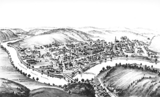
Bird’s-eye maps gained popularity during the latter half of the 19th and the early years of the 20th centuries. This popular form of commercial art, not generally drawn to scale, provided a three-dimensional portrait of street layouts, transportation routes, individual buildings, and major physical features of the vicinity.
Fowler’s implements were few: folding ruler, compass, magnifying glass, parallelogram, and yardstick. To achieve the bird’s-eye view, Fowler and other mapmakers would climb to the highest appropriate spot, perhaps a tall building, steeple, mountainside, or water tower. There they got an overview of the general structures and landmarks and their relation to the rivers, mountains, and other physical features, making rough drawings of their views. Then they drew individual sketches of houses, businesses, churches, parks, trees, and other landmarks, finally combining their work into one detailed map.
Written by Debra K. Sullivan