 | Back to e-WV
| Back to e-WV
| Back to e-WV
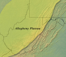
The Allegheny Plateau makes up about half of the Appalachian Mountains and most of West Virginia. Near the Ohio River the maximum elevations of the Allegheny Plateau are about 1,000 feet above sea level, increasing eastward to more than 4,000 feet as the Allegheny Front is approached. All streams on the Allegheny Plateau follow an irregular dendritic or tree-like pattern, eventually draining to the Ohio River. The plateau is dissected with razorback ridges, held up by strong sandstone like the Pottsville, and youthful valleys cut deep into shale.
Throughout their history the Appalachians have been repeatedly uplifted. As streams such as the Little Kanawha, Elk, Guyandotte, New, Monongahela, and others were rejuvenated with the uplifts, meanders became entrenched, with valley slopes steeper below than above and often at grades of 35 to 40 degrees. The plateau is so minutely and deeply dissected that valley bottoms are almost always narrow.
Valleys are the primary locations of human activities, and settlement follows the creeks and rivers. All the streams except the New River originate on the plateau. The New, older than the plateau itself, cuts through the plateau in a gorge averaging 1,000 feet deep.
The Allegheny Plateau is rich in natural resources. It is covered with regrowth forests of central hardwoods. Another resource is coal, first reported in 1742 on the Coal River in present Boone County. The coming of railroads in the 19th century made the coal accessible, and mining, with its coal towns, company stores, and burgeoning work force, transformed the region. Petroleum and natural gas are widespread. The natural gas and glass sand of near pure silica content supported a glass industry that remains in several plateau counties, including Cabell, Wood, Hancock, Lewis, and Ritchie.
With a surface more rugged than any region east of the Rockies, the plateau does not have much good farm land. The dominant agricultural land use is related to livestock, including the production of grass and hay. Tobacco is a specialty crop of the plateau, with 95 percent of the state’s total raised in six plateau counties, centering on Mason and Putnam. About 83 percent of the state’s population and all cities with a population more than 10,000, excepting Bluefield and Martinsburg, are in the Allegheny Plateau.
Written by Howard G. Adkins
Fenneman, Nevin M. Physiography of Eastern U.S.. New York: McGraw-Hill, 1938.
Hunt, Charles B. Physiography of the U.S. San Francisco: W. H. Freeman & Co., 1967.
United States Geological Survey Maps, Scale 1:250,000. Bluefield, Canton, Charleston, Charlottesville, Clarksburg, Cumberland, Huntington & Jenkins quadrangles.