 | Back to e-WV
| Back to e-WV
| Back to e-WV
The Potomac River begins at a spring in the northeastern corner of Tucker County. The spring is the site of a small monolith, a replica of the first Fairfax Stone that once marked the boundary of the land grant to the sixth Lord Fairfax, which ran to the farthest headwaters of the Potomac. This is the North Branch of the Potomac, which flows 97 miles to its confluence with the South Branch. The Potomac forms the boundary between West Virginia and Maryland from the Fairfax Stone to Harpers Ferry, and from Harpers Ferry to the Chesapeake Bay it is the boundary between Maryland and Virginia. The river itself belongs to Maryland under a 1632 grant by Charles I, but Virginia (and consequently West Virginia) gained water rights under a 1785 compact. The total length from spring to bay is 287 miles.
The other main fork of the Potomac is the South Branch, which flows down from its highest headwaters in Highland County, Virginia, through Pendleton, Grant, Hardy, and Hampshire counties. The North and South branches, with the North and South forks of the South Branch and other Potomac tributaries and the main river itself, together drain all of the Eastern Panhandle and Potomac Highlands of West Virginia, and much of neighboring Virginia and Maryland. The Shenandoah River, a major tributary, enters the Potomac at Harpers Ferry.
The Potomac is rich in history and prehistory. Archeologists believe that humans were present as hunter-gatherers in the Potomac watershed before 10,000 B.C., and by the arrival of the early European traders and settlers Indian communities were commonplace on the lower Potomac. The Potomac Valley Indians were great traders. The name itself is derived from a 1608 map by Capt. John Smith that indicated the location of a tribe, Potowmeck, and was translated as the ‘‘landing place for goods’’ or ‘‘emporium.’’
Aiming to develop a transportation corridor into the Appalachians, George Washington and others formed the Potowmack Company in 1784, but the company’s navigational improvements failed to make river commerce feasible for more than several months of the year. A successor, the Chesapeake & Ohio Canal Company, built a canal on the Maryland side of the river that parallels the Potomac between Cumberland, Maryland, and Washington. On May 3, 1924, a devastating flood at Harpers Ferry wiped out a highway bridge and permanently shut down the canal. Today the Chesapeake & Ohio Canal National Historical Park preserves all 184.5 miles of the waterway, the most intact example of America’s canal era.
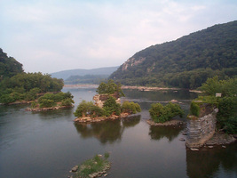
George Washington also gave encouragement to James Rumsey, the inventor of a steamboat that Rumsey successfully demonstrated on the Potomac at Shepherdstown in 1787. In 1790, at the direction of Congress, Washington selected the site for the U. S. capital at the confluence of the Potomac and what is today the Anacostia River. President Washington had a national armory located at Harpers Ferry, where the Shenandoah joins the Potomac. In Civil War times the Potomac River served as the boundary between the Union and the Confederacy.
The Potomac is noted for its great beauty and its recreational value. The South Branch, with its North and South forks, runs down from West Virginia’s highest mountains. Seneca Rocks, West Virginia’s best-known natural landmark, stands on the bank of the North Fork in Pendleton County. Nearby Spruce Knob, elevation 4,861 feet, is the highest point in the state. The South Branch and its tributaries flow through both the Monongahela and George Washington national forests.
Generally, the North Branch valley is an old industrial area, rich in mining and manufacturing history. The North Branch is dammed above Piedmont, where the Jennings Randolph Lake helps to regulate water quality downstream. The valley provided a vital transportation route from as early as the French and Indian War, and still does today.
The worst flood of the Potomac took place on March 19, 1936, when the river at Harpers Ferry reached a record 36.5 feet, more than 18 feet above flood stage. On November 6, 1985, the Potomac crested more than 12 feet above flood stage at Harpers Ferry. The 1985 flood was the most damaging in the state’s history, with 47 deaths in West Virginia and approximately $1.2 billion in damage. Other known floods occurred on the Potomac in 1753, 1810, 1843, 1852, 1870, 1889, 1896, and 1942.
Although the Potomac is one of the cleanest rivers of the Atlantic Seaboard and is being further improved through efforts of federal, state, and local governments, it still has critical problems. Acid drainage from abandoned coal mines pollutes the North Branch, while sediment, herbicide, pesticide, and chemical fertilizer runoff from suburban development and farming operations enter the river system at many points. Agricultural runoff associated with the growing poultry industry in the upper Shenandoah Valley and the South Branch and hogs in western Maryland has been an issue in recent years. The lower river suffers from the urban runoff of oils and heavy metals from streets, parking lots, and abandoned industrial sites on the Anacostia River, which ranks high as one of America’s dirtiest urban rivers.
Written by Gilbert Gude
Gutheim, Frederick. The Potomac. Baltimore: Johns Hopkins University Press, 1986.
Hyde, Arnout Jr. & Ken Sullivan. The Potomac: A Nation's River. Charleston: Cannon Graphics, 1993.
Ator, Scott W., et al. "Water Quality in the Potomac River Basin, 1992-1996," Circular 1166. United States Geological Survey, 1998.