 | Back to e-WV
| Back to e-WV
| Back to e-WV
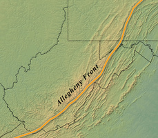
The Allegheny Front is a bold southeast-facing escarpment of resistant Pocono and Pottsville sandstone two to three miles wide, extending along an irregular line from Keyser to Bramwell. East of the front is the Ridge and Valley Province, and to the west are the wedge-like Allegheny Mountains and the Allegheny Plateau. Unbroken slopes of 1,000 feet are not uncommon to the front.
The Allegheny Front is marked by an irregular line of high elevations. From 3,500 feet west of Keyser the front rises steadily to 4,861 feet at Spruce Knob, the highest point in the state. In this general region along the eastern segment of the Pendleton-Randolph county line, the front is offset ten to 12 miles to the northwest, west of the Greenbrier River, and then follows southwesterly along the line of Shavers (4,193 feet), Back Allegheny (4,840 feet), and Droop (3,136 feet) mountains. Southwest of Droop Mountain the front is broken into spur-like projections with elevations up to 3,500 feet. Near Alderson the front lies athwart the Greenbrier River, making a ten-to-12-mile jog southeast to Little Mountain (2,800 feet), and is even more pronounced with ridges to the east higher at 4,000 feet. About 12 miles southwest of the New River, the front near Princeton is again offset some six to seven miles to the northwest, and the face of the escarpment is eroded into finger-like projections that extend to the valley of the Bluestone River. The Allegheny Front exits the state near Bramwell with elevations of 3,000 feet.
Wind and water gaps through the escarpment have influenced human and animal movement along specific routes, and its physical nature was not attractive to human settlement, though Spruce Knob, Dolly Sods, Cass Scenic Railroad, and Droop Mountain Battlefield are attractions now associated with the Allegheny Front.
Written by Howard G. Adkins
Fenneman, Nevin M. Physiography of Eastern U.S.. New York: McGraw-Hill, 1938.
West Virginia Atlas & Gazetteer. Yarmouth, ME: Delorme, 1997.
United States Geological Survey Maps, Scale 1:250,000. Bluefield, Charleston, Charlottesville & Cumberland quadrangles.