 | Back to e-WV
| Back to e-WV
| Back to e-WV
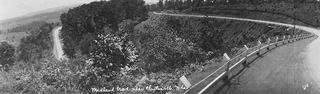
The Midland Trail is the national east-west automobile route constructed in the 1930s, designated as U.S. 60 and crossing the center of America from the Chesapeake Bay to the Pacific Ocean. In West Virginia, the Midland Trail was the first state-maintained highway. In 1988, the section from White Sulphur Springs to the state capitol was designated as West Virginia’s first state scenic highway. In 2000 this eastern portion of West Virginia’s Midland Trail was designated a national scenic byway, and the state designation as a scenic byway was extended from the state capitol to the Kentucky border at Kenova.
This route has an ancient beginning as a buffalo trail and was later used by Indians. In 1774, Gen. Andrew Lewis used it to march his 1,000-man army from today’s Lewisburg to Point Pleasant, where he defeated Chief Cornstalk. In 1824, a private Virginia company upgraded the route into the James River & Kanawha Turnpike.
After 1873, the turnpike fell into disrepair because the Chesapeake & Ohio Railway had been completed from the Chesapeake Bay to the Ohio River. The Midland Trail carried only local traffic during the era of fast and comfortable railway travel. In the 1930s, it was paved and reborn as a national highway after the American Automobile Association asked federal authorities to develop a national highway system. Today the Midland Trail is a tourist destination and historic travel route representing the ‘‘Golden Age of the American Automobile.’’
Written by Larry L. Rowe