 | Back to e-WV
| Back to e-WV
| Back to e-WV
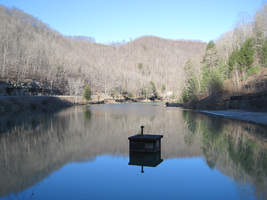
Situated in the 12,854-acre Laurel Lake Wildlife Management Area about 12 miles northeast of Lenore off State Route 65 in Mingo County, Laurel Lake has 29 acres of surface water for fishing, swimming, and boating. The lake and its surrounding terrain are managed by the West Virginia Division of Natural Resources on property owned by Island Creek Coal Company, Georgia Pacific Corporation, and the Cotiga Development Corporation, which entered into the original lease to construct the lake in 1960.
Laurel Lake is surrounded by rugged topography with steep slopes and hills up to 1,700 feet above sea level. A mixed hardwood forest includes oak and hickory with an understory of dogwood, sassafras, sumac, blackberry, and grape. The lake is stocked with trout monthly from February through May. Other fish include channel catfish, large mouth bass, and bluegill. Minnow use is prohibited as bait. Game include deer (which may be hunted by bow only), turkey, raccoon, grouse, and squirrel. The lake has standard campsites with water, toilets, and showers. Laurel Lake also has other recreational facilities such as game courts, a playground, hiking trails, boat rentals, a skeet range, and picnicking areas; however, all recreational facilities were closed in January 2016 due to budget cuts. Operating funds for Lake Laurel are derived from fishing, hunting and trapping license fees, supplemented with swimming and camping fees.
Written by Larry Sonis
Erwin, Robert B. West Virginia Gazetteer of Physical and Cultural Place Names. Morgantown: West Virginia Geological & Economic Survey, 1986.