 | Back to e-WV
| Back to e-WV
| Back to e-WV
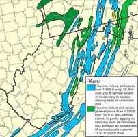
Many of the most scenic areas of West Virginia are found in the eastern and southeastern parts of the state where carbonate rocks (limestone and dolomite) are exposed to the surface. The landscape formed by the slow chemical dissolution of soluble rocks is called ‘‘karst’’ by geologists. The results of chemical weathering of rocks are expressed by the formation of sinkholes (dolines), sinking streams (‘‘lost rivers’’), large springs, and caves.
The most characteristic feature of a karst landscape is the lack of surface streams; most of the water in these areas is flowing in underground channels through caves. The sinking streams and drainage through the bottoms of the numerous sinkholes divert most of the rainfall to underground routes where the water may travel for several miles before returning to the surface at large springs. Although the karst aquifers of West Virginia are some of the most productive in the state, the very localized occurrence of ground water in cave conduits and the lack of surface drainage sometimes make the karst areas seem water-poor. The ground water in karst areas is also especially susceptible to contamination because of the fast flow rates (sometimes greater than one mile per day) and little opportunity for filtering of the water. Many of the springs in limestone regions contain high bacteria counts and should not be used as a drinking water source without treatment.
Several large West Virginia creeks sink and run underground for part of their course. The Lost River near Wardensville sinks completely during low conditions and reemerges as the Cacapon River. Hills Creek in Pocahontas County sinks completely into a large cave, and the water splits. Some of the flow goes under Droop Mountain to Locust Creek and some goes underground about 11 miles south to Spring Creek in Greenbrier County. Milligan Creek in Greenbrier County rises and sinks at least four times before its resurgence at Davis Spring at Fort Spring. Davis Spring drains an area of 72 square miles and with an average flow of about 110 cubic feet per second is the largest spring in West Virginia. Culverson Creek sinks at the base of a limestone cliff west of Frankford and re-surges four miles to the east in a series of springs along Spring Creek.
The most extensive karst features in West Virginia may be found in the Greenbrier valley of Greenbrier, Monroe, and Pocahontas counties. The towns of Union and Lewisburg are situated on karst sinkhole plains, and Lewisburg lies mostly within a compound sinkhole. The scenic course of U.S. 219 from the Virginia state line in Monroe County north through Greenbrier County traverses a mature sinkhole plain. The sink of the Lost River in Hardy County is just upstream of the State Route 55 bridge, and the river reemerges a mile downstream as the Cacapon River. The karst relief of Berkeley and Jefferson counties is more subtle, but numerous ‘‘ribbons’’ of exposed carbonate rocks called karren are evident in the fields and pastures of the area.
Written by William K. Jones
Jones, W. K. Karst Hydrology Atlas of West Virginia. Charles Town: Karst Waters Institute, 1997.
McColloch, Jane S. Springs of West Virginia. Morgantown: West Virginia Geological & Economic Survey, 1986.
White, W. B. Geomorphology and Hydrology of Karst Terrains. New York: Oxford University Press, 1988.