 | Back to e-WV
| Back to e-WV
| Back to e-WV
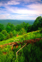
Cheat Mountain extends from the Tucker-Randolph county line near Kerens southward approximately 48 miles to Thorny Flat at the headwaters of Shavers Fork in Pocahontas County. The northern portion consists of sharply folded sedimentary rock with steep slopes and narrow ridges. The main bulk of Cheat Mountain is a southward extension of Backbone Mountain and McGowan Mountain and is separated from them by the gaps of Dry Fork River above Parsons and Shavers Fork below Bowden. Southward, Cheat Mountain forms the dividing ridge between Tygart Valley River and Shavers Fork.
The summits of Cheat Mountain are formed by escarpments of hard conglomerates. The summits are uniformly high with many peaks, ranging from 4,000 feet at Pond Lick Mountain at the northern end, to an unnamed summit southeast of Mace, Pocahontas County, which is 4,840 feet. On the west slope, toward Tygart Valley River, the slopes are generally steep and abrupt. On the east, the descent is more sloping to form a high plateau extending to Shavers Fork, which is 2,218 feet at Bowden rising to 4,660 feet at Thorny Flat. East of Shavers Fork, the plateau extends to the summits of Back Allegheny and Shavers mountains. This entire plateau is often referred to as Cheat Mountain. The high elevation and abundant rainfall on these summits and on the plateau gave rise to an almost unbroken red spruce forest.
Cheat Mountain was a formidable barrier to the westward movement of early settlers. The Staunton-Parkersburg Turnpike, now U.S. 250, eventually crossed the mountain at Cheat Bridge at an elevation of 3,557 feet. During the Civil War, Union troops set up a camp near Cheat Bridge, known as Fort Milroy, to protect this crossing. Remains of this encampment and graves of Union soldiers who died there are still visible. These soldiers cut the first timber in the Cheat Mountain area with a small steam-powered circular sawmill. A small but important skirmish was fought there in September 1861.
After the Civil War, the magnificent red spruce timber attracted the attention of lumbermen. W. S. Dewing and Sons made extensive purchases and commenced cutting timber with the intention of floating it down Shavers Fork and Cheat River to their mill at Point Marion, Pennsylvania. Dewing introduced the first logging locomotive in this area, a small Shay engine hauled in by wagon. This endeavor proved unsuccessful, and in 1899 he sold his holdings to the newly formed West Virginia Pulp & Paper Company. The company built a large band sawmill at the present location of Cass, Pocahontas County, and built the town to house the workers. Decades later, in 1974, the southern portion of Cheat Mountain attracted another venture, now known as Snowshoe Mountain Resort with premier skiing, golf, condominiums, lodges, and restaurants.
Cheat Mountain and the associated Shavers Fork plateau form a high ecosystem that is unique in the eastern United States. The region is host to more than 50 rare northern species such as the Cheat Mountain salamander, the West Virginia northern flying squirrel, snowshoe hare, goshawk, Bartrams serviceberry, balsam fir, and Canada honeysuckle.
Written by Roy B. Clarkson
Price, Paul H. West Virginia Geological & Economic Survey. Pocahontas County. Wheeling News Litho, Co., 1929.
Reger, David B. West Virginia Geological & Economic Survey. Randolph County. Morgantown: West Virginia University, 1931.