 | Back to e-WV
| Back to e-WV
| Back to e-WV
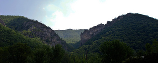
The Champe Rocks are two sandstone masses that rise on the east side of the North Fork of the South Branch of the Potomac River, six miles north of Seneca Rocks on State Route 28-55 in Pendleton County. They stand some 900 feet above the valley floor and overlook the narrow river plain near the site where John Champe, a Revolutionary War soldier, possibly lived for a short period of time.
John Champe was sent by Gen. George Washington in October 1780 to kidnap the traitor Benedict Arnold. Champe pretended to be an American deserter and joined the British, but he was unable to kidnap Arnold. He was forced to serve with the British Army until he escaped to rejoin the American forces. Washington, believing that the British would show no mercy if Champe were to be captured by them, discharged Champe and encouraged him to establish his home on Abram’s Creek in Grant County, between present Scherr and Mount Storm. After residing there for two years, Champe and his family relocated elsewhere before eventually settling in Craig County, Virginia, where he died.
The Champe Rocks are an outcropping of Tuscarora sandstone, the same hard stone which makes up Seneca Rocks.
Written by Donald L. Rice
West Virginia Writers' Project. West Virginia: A Guide to the Mountain State. New York: Oxford University Press, 1941.
Judy, E. L. History of Grant and Hardy Counties. Charleston Printing, 1951.
Morton, Oren F. A History of Pendleton County. Dayton, VA: Ruebush-Elkins, 1910, Reprint, Regional Pub. Co., 1974.