 | Back to e-WV
| Back to e-WV
| Back to e-WV
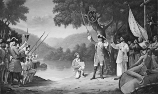
In the mid-1700s, France and Great Britain stood on the brink of war for control of the Ohio Valley, including most of present West Virginia. French claims on the region were based on expeditions by the explorer La Salle in 1669. In 1749, the governor of Canada, Marquis de la Galissonnière, dispatched Pierre-Joseph Celoron de Blainville (1693–1759) down the Allegheny and Ohio rivers to strengthen France’s position. In August, Celoron led 230 Canadian militia and Indian guides to the mouth of Wheeling Creek. His party buried a leaden plate at the junction of Wheeling Creek and the Ohio River, claiming all territory drained by the streams in the name of Louis XV, king of France.
Celoron’s party traveled down the Ohio to the mouth of the Kanawha River at the present site of Point Pleasant and buried another plate on August 18. In all, he buried four plates along the Ohio, but the effort was fruitless. Great Britain’s victory in the ensuing French and Indian War (1754–63) forced the French from the region, and France surrendered all claims on the Ohio Valley as part of the Treaty of Paris. The Point Pleasant plate, by then a historical curiosity, was found by a boy playing on the riverbank in 1846.
Written by Stan Bumgardner
West Virginia Writers' Project. West Virginia: A Guide to the Mountain State. New York: Oxford University Press, 1941.
Cometti, Elizabeth & Festus P. Summers. The Thirty-Fifth State: A Documentary History of West Virginia. Morgantown: West Virginia University Library, 1966.