 | Back to e-WV
| Back to e-WV
| Back to e-WV
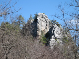
Also known as Castle Rock, Caudy’s Castle is a geologic formation located near the Forks of Cacapon, west of Bloomery in Hampshire County. Towering 400 feet above the forested valley and the Cacapon River, the fine white Oriskany Sandstone formation has been colored a tan hue by time and iron deposits. A trail ascending the landmark cliff begins near the west face and winds northeast to the jagged peak. The prominence provides a spectacular view of the surrounding mountains and valley.
The cone-shaped megalith gained its name during the French and Indian War when pioneer settlers, led by frontiersman James Caudy, purportedly took refuge in its craggy recesses. The constricted rock ledges allowed only single-file passage, and one by one, the Indians pursuing the fleeing settlers were pushed to their deaths by Caudy. Safely cloistered in a rocky recess, he prodded them with his long rifle as they negotiated the narrow passes.
Written by Robert B. Wolford
Comstock, Jim, ed. West Virginia Heritage Encyclopedia vol. 4. Richwood: Jim Comstock, 1976.
Maxwell, Hu & H. L. Swisher. History of Hampshire County. Morgantown: A. B. Boughner, 1897, Reprint, McClain, 1972.
White, I. C. West Virginia Geological & Economic Survey. Hampshire and Hardy Counties. Morgantown Printing & Binding, 1927.